Kuhköpfe
Kuhköpfe is a peak in Bach, Reutte District, Tyrol and has an elevation of 2,064 metres. Kuhköpfe is situated nearby to the locality Griestal, as well as near P.2616.| Tap on a place to explore it |
Places of Interest
Highlights include Holzgauer Wetterspitze and Feuerspitze.
Holzgauer Wetterspitze
Peak
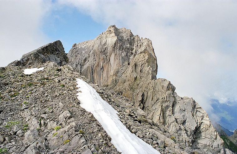 Holzgauer Wetterspitze is a mountain in the Lechtal Alps of Tyrol, Austria. The elevation at its peak is 2,895 metres. It is located in the district of Reutte, 7 kilometres south of Holzgau, for which its name is derived, and 5 kilometres east of Kaisers.
Feuerspitze
Peak
 Feuerspitze is a mountain in the Lechtal Alps of Tyrol. The elevation at its peak is 2,852 metres. Feuerspitze is located 7 kilometres southeast of Holzgau. From the Ansbacher Hütte, it takes three hours to climb to the summit of Feuerspitze.
Alplespleisspitze Southern Summit
Peak

Photo: Harald Hetzner, CC0.
Alplespleisspitze Southern Summit is a peak.
Places in the Area
Nearby places include Steeg and Holzgau.
Steeg
Village

Photo: Simonm, CC BY-SA 3.0.
Steeg is a municipality in the district of Reutte in the Austrian state of Tyrol.
Holzgau
Village

Photo: Moosi moo, CC BY-SA 3.0 de.
Holzgau is a municipality in the district of Reutte in the Austrian state of Tyrol.

Kuhköpfe
- Type: Peak with an elevation of 2,064 metres
- Description: ridge prominence of Guflespitze in the Lechtal Alps in Tyrol, Austria
- Categories: ridge prominence and landform
- Location: Bach, Reutte District, Tyrol, Austria, Central Europe, Europe
- View on OpenStreetMap
Latitude
47.217° or 47° 13′ 1″ northLongitude
10.3463° or 10° 20′ 47″ eastElevation
2,064 metres (6,772 feet)Open location code
8FVG688W+RGOpenStreetMap ID
node 13100005139OpenStreetMap feature
natural=peakWikidata ID
Q136902062
This page is based on OpenStreetMap, Wikidata, and Wikimedia Commons.
We’d love your help improving our open data sources. Thank you for contributing.
Satellite Map
Discover Kuhköpfe from above in high-definition satellite imagery.
In Other Languages
“Kuhköpfe” goes by many names.
- German: “Kuhköpfe”
- “Kuhköpfe”
Localities in the Area
Explore places such as Griestal and P.2616.
Notable Places Nearby
Highlights include Guflekopf and Falmedonjoch.
Tyrol: Must-Visit Destinations
Delve into Innsbruck, Kufstein, Lienz, and Kitzbühel.
Curious Peaks to Discover
Uncover intriguing peaks from every corner of the globe.
About Mapcarta. Data © OpenStreetMap contributors and available under the Open Database License". Text is available under the CC BY-SA 4.0 license, except for photos, directions, and the map. Photo: Traveler100, CC BY-SA 3.0.