Healthway Medical Centre
Healthway Medical Centre is a doctor’s office in Manitoba, Prairies which is located on Portage Avenue. Healthway Medical Centre is situated nearby to Jesus Christ Is Lord Universal Church, as well as near Home Street Mennonite Church.| Tap on a place to explore it |
Places of Interest Nearby
Highlights include Canada Life Centre and Greenway School.
Canada Life Centre
Stadium
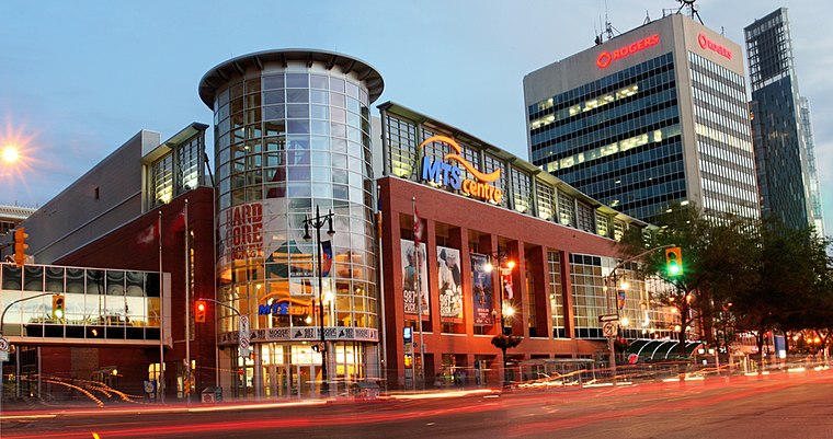 Canada Life Centre is an indoor arena in downtown Winnipeg, Manitoba, Canada. It is the home of the National Hockey League's Winnipeg Jets and their American Hockey League affiliate, the Manitoba Moose. Canada Life Centre is situated 2 km east of Healthway Medical Centre.
Greenway School
School
The Winnipeg School Division is a school division in Winnipeg, Manitoba. With 78 schools, it is the largest of six public school divisions in Winnipeg, as well as the largest and oldest school division in Manitoba. Greenway School is situated 420 metres northwest of Healthway Medical Centre.
Westminster United Church
Church

Photo: Krazytea, CC BY-SA 3.0.
Westminster United Church is a Mainline Protestant church in Winnipeg, Manitoba, Canada. It is part of the United Church of Canada. The church was built between 1910 and 1912, and has been recognized for its historical and architectural significance, designated a Manitoba Provincial Heritage Site in 1992 and awarded a Conservation Award in 2020. Westminster United Church is situated 650 metres southeast of Healthway Medical Centre.
Places in the Area
Nearby places include West End and Wolseley.
West End
Suburb
 The West End is a mainly residential area of Downtown Winnipeg, Manitoba, Canada. It includes the neighbourhoods of Armstrong's Point, Colony, Daniel McIntyre, Minto, Sargent Park, Spence, St.
Wolseley
Neighborhood
Photo: Krazytea, CC BY-SA 3.0.
Wolseley is a neighbourhood located within the West End of Winnipeg, Manitoba. It is named for field marshal Sir Garnet Wolseley, a British Army officer who came to Manitoba in 1870 to suppress the Red River Rebellion.
Armstrong’s Point
Neighborhood

Photo: Qwekiop147, CC BY 3.0.
Armstrong's Point is a neighbourhood in Winnipeg, Manitoba. It is located in the West End of the city and in a large bend in the Assiniboine River. The land was developed in the late 19th and early 20th centuries as a residential district.
Healthway Medical Centre
- Type: Doctor’s office
- Address: 865 Portage Avenue
- Category: health care
- Location: Manitoba, Prairies, Canada, North America
- View on OpenStreetMap
Latitude
49.88605° or 49° 53′ 10″ northLongitude
-97.1686° or 97° 10′ 7″ westOpen location code
86X4VRPJ+CHOpenStreetMap ID
node 13125761044OpenStreetMap feature
amenity=doctorsOpenStreetMap feature
healthcare=doctor
This page is based on OpenStreetMap, Wikidata, and Wikimedia Commons.
We’d love your help improving our open data sources. Thank you for contributing.
Satellite Map
Discover Healthway Medical Centre from above in high-definition satellite imagery.
Notable Places Nearby
Highlights include Jesus Christ Is Lord Universal Church and Home Street Mennonite Church.
Nearby Places
Explore places such as Healthway Pharmacy and Makka Halal Meat & Grocery.
Manitoba: Must-Visit Destinations
Delve into Winnipeg, Churchill, Brandon, and Thompson.
Curious Doctor’s Offices to Discover
Uncover intriguing doctor’s offices from every corner of the globe.
About Mapcarta. Data © OpenStreetMap contributors and available under the Open Database License". Text is available under the CC BY-SA 4.0 license, except for photos, directions, and the map. Photo: Wikimedia, CC0.