Mithraeum
Mithraeum is a historic site in Charleston County, South Carolina. Mithraeum is situated nearby to Saint Lawrence Cemetery, as well as near Kahal Kadosh Beth Elohim Cemetery.| Tap on a place to explore it |
Places of Interest Nearby
Highlights include The Citadel and Martin Park.
The Citadel
College
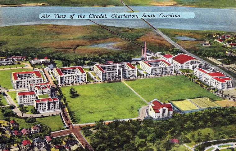
Photo: Wikimedia, Public domain.
The Citadel Military College of South Carolina is a public senior military college in Charleston, South Carolina, United States. Established in 1842, it is the third oldest of the six senior military colleges in the United States. The Citadel is situated 2 miles southwest of Mithraeum.
Martin Park
Park
Martin Park is a public park in Charleston, South Carolina. It is bounded by Lee, Jackson, Hanover, and America Streets. The park includes a softball field, a playground, a basketball court, tennis courts, community center and a large swimming pool. Martin Park is situated 1¼ miles south of Mithraeum.
Hampstead Mall
Park
Hampstead Mall is a public park in Charleston, South Carolina, of 140,625 square feet in the Hampstead Village neighborhood at the intersection of Columbus and America Streets. Hampstead Mall is situated 1½ miles south of Mithraeum.
Places in the Area
Nearby places include Hampstead Village and Hampton Park Terrace.
Hampstead Village
Quarter
Hampstead Village is a neighborhood in Charleston, South Carolina in the US, also known as the Eastside or the East Side. A prominent merchant, Henry Laurens, bought several tracts totaling 99 acres where Hampstead Village is today.
Hampton Park Terrace
Neighborhood

Photo: ProfReader, CC BY-SA 3.0.
Hampton Park Terrace is the name both of a neighborhood and a National Register district located in peninsular Charleston, South Carolina. The neighborhood is bounded on the west by The Citadel, on the north by Hampton Park, on the east by Rutledge Ave, and on the south by Congress St.
Wraggborough
Quarter
Wraggborough is a neighborhood in downtown Charleston, South Carolina, named after slave trader Joseph Wragg, and noted for its association with the slave trade. Wraggborough is situated 2 miles south of Mithraeum.
Mithraeum
- Type: Historic site
- Inscription: “WMB. Smith”
- Categories: tourist attraction and tourism
- Location: Charleston County, South Carolina, South, United States, North America
- View on OpenStreetMap
Latitude
32.81655° or 32° 48′ 60″ northLongitude
-79.94174° or 79° 56′ 30″ westOpen location code
8742R385+J8OpenStreetMap ID
node 13306784382OpenStreetMap feature
historic=place_of_worship
This page is based on OpenStreetMap, Wikidata, and Wikimedia Commons.
We’d love your help improving our open data sources. Thank you for contributing.
Satellite Map
Discover Mithraeum from above in high-definition satellite imagery.
Places with the Same Name
Discover other places named “Mithraeum”.
Notable Places Nearby
Highlights include Saint Lawrence Cemetery and Kahal Kadosh Beth Elohim Cemetery.
Nearby Places
Explore places such as Charleston Light Dragoons and Bridgeview Village.
South Carolina: Must-Visit Destinations
Delve into Columbia, Charleston, Greenville, and Myrtle Beach.
Curious Historic Sites to Discover
Uncover intriguing historic sites from every corner of the globe.
About Mapcarta. Data © OpenStreetMap contributors and available under the Open Database License". Text is available under the CC BY-SA 4.0 license, except for photos, directions, and the map. Photo: Rastapopulous, CC BY-SA 3.0.