L’Aubresset
L’Aubresset is a hamlet in Razac-sur-l’Isle, Arrondissement of Périgueux, Nouvelle-Aquitaine. L’Aubresset is situated nearby to the hamlet Bellevue, as well as near La Combe du Cerf.| Tap on a place to explore it |
Places of Interest
Highlights include Château de la Rolphie and Château de la Jarthe.
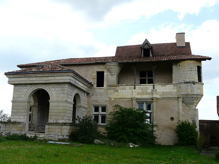
Château de la Jarthe
Castle
The Château de la Jarthe is a château during the 12th century in Coursac, Dordogne, Nouvelle-Aquitaine, France. Château de la Jarthe is situated 3½ km south of L’Aubresset.
Église Notre-Dame de Razac-sur-l’Isle
Church

Photo: Père Igor, CC BY-SA 4.0.
Église Notre-Dame de Razac-sur-l’Isle is a church, which is situated 3 km west of L’Aubresset.
Places in the Area
Nearby places include Marsac-sur-l’Isle and Annesse-et-Beaulieu.
Marsac-sur-l’Isle
Village

Photo: Père Igor, CC BY-SA 3.0.
Marsac-sur-l'Isle is a commune in the Dordogne department in Nouvelle-Aquitaine in southwestern France. Marsac-sur-l’Isle is situated 3 km northeast of L’Aubresset.
Annesse-et-Beaulieu
Village

Photo: Père Igor, CC BY-SA 3.0.
Annesse-et-Beaulieu is a commune in the Dordogne department in Nouvelle-Aquitaine in southwestern France. Annesse-et-Beaulieu is situated 4 km northwest of L’Aubresset.
Montrem
Village

Photo: Père Igor, CC BY-SA 3.0.
Montrem is a commune in the Dordogne department in Nouvelle-Aquitaine in southwestern France. Montrem is situated 4½ km southwest of L’Aubresset.
L’Aubresset
- Type: Hamlet
- Category: locality
- Location: Razac-sur-l’Isle, Arrondissement of Périgueux, Dordogne, Nouvelle-Aquitaine, France, Europe
- View on OpenStreetMap
Latitude
45.15861° or 45° 9′ 31″ northLongitude
0.63575° or 0° 38′ 9″ eastOpen location code
8FQ25J5P+C7OpenStreetMap ID
node 13316534491OpenStreetMap feature
place=hamlet
This page is based on OpenStreetMap, Wikidata, and Wikimedia Commons.
We’d love your help improving our open data sources. Thank you for contributing.
Satellite Map
Discover L’Aubresset from above in high-definition satellite imagery.
In Other Languages
“L’Aubresset” goes by many names.
- Occitan (post 1500): “L’Aubre Sec”
Localities in the Area
Explore places such as Bellevue and La Combe du Cerf.
Notable Places Nearby
Highlights include Salle polyvalente and Cimetière de Razac-sur-l’Isle.
Dordogne: Must-Visit Destinations
Delve into Périgueux, Sarlat-la-Canéda, Bergerac, and Rocamadour.
Curious Hamlets to Discover
Uncover intriguing hamlets from every corner of the globe.
About Mapcarta. Data © OpenStreetMap contributors and available under the Open Database License". Text is available under the CC BY-SA 4.0 license, except for photos, directions, and the map. Photo: Sémhur, CC BY-SA 3.0.