大阪府済生会泉尾第二病院
大阪府済生会泉尾第二病院 is a hospital in Taisho-ku, Osaka, Osaka. 大阪府済生会泉尾第二病院 is situated nearby to Taisho Post Office, as well as near Taisho Sangenya Post Office.| Tap on a place to explore it |
Places of Interest Nearby
Highlights include Kyocera Dome Osaka and Taisho.
Kyocera Dome Osaka
Stadium

Photo: Wikimedia, CC BY-SA 3.0.
The Kyocera Dome Osaka is a baseball stadium located in Osaka, Osaka Prefecture, Japan. Opened in 1997, the stadium was the home field of the Osaka Kintetsu Buffaloes. Kyocera Dome Osaka is situated 560 metres north of 大阪府済生会泉尾第二病院.
Taisho
Railway stop

Photo: BJP039, CC BY-SA 3.0.
Taisho Station is a combined railway station and metro station located in Taishō-ku, Osaka, Japan. The station is served by the Osaka Loop Line and the Nagahori Tsurumi-ryokuchi Line. Taisho is situated 160 metres northeast of 大阪府済生会泉尾第二病院.
Iwasaki Bridge
Bridge

Photo: Facial expression, CC BY-SA 3.0.
Iwasaki Bridge is situated 330 metres north of 大阪府済生会泉尾第二病院.
Places in the Area
Nearby places include Nishi-ku and Naniwa-ku.
Nishi-ku
Suburb

Photo: Wikimedia, CC BY-SA 3.0.
Nishi is one of 24 wards of Osaka, Japan. It is in the west of central Osaka, and is generally flat. 80% of the area was destroyed by bombing in World War II, and was not regenerated until the mid-1960s.
Naniwa-ku
Suburb

Photo: 螺钉, CC BY-SA 3.0.
Naniwa-ku is one of 24 wards of Osaka, Japan. It has an area of 4.37 km2, and a population of 51,567.
Minato-ku
Suburb
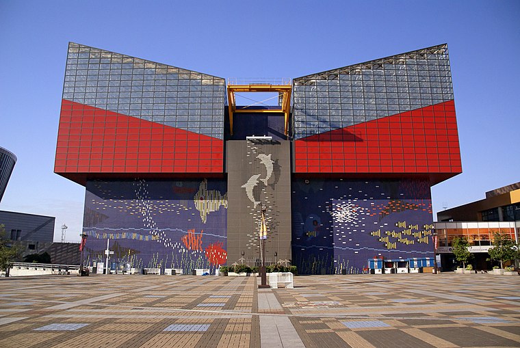
Photo: 663highland, CC BY 2.5.
Minato is one of 24 wards of Osaka, Japan. It has an area of 7.9 km2, and a population of 84,961. Literally translated, Minato-ku means "Harbor Ward".
大阪府済生会泉尾第二病院
- Type: Hospital
- Category: health care
- Location: Taisho-ku, Osaka, Osaka, Kansai, Japan, East Asia, Asia
- View on OpenStreetMap
Latitude
34.6644° or 34° 39′ 52″ northLongitude
135.47747° or 135° 28′ 39″ eastOpen location code
8Q6QMF7G+QXOpenStreetMap ID
node 1422989975OpenStreetMap feature
amenity=hospital
This page is based on OpenStreetMap, Wikidata, and Wikimedia Commons.
We’d love your help improving our open data sources. Thank you for contributing.
Satellite Map
Discover 大阪府済生会泉尾第二病院 from above in high-definition satellite imagery.
Notable Places Nearby
Highlights include Taisho Post Office and Taisho Sangenya Post Office.
Nearby Places
Explore places such as 済生会泉尾第二病院 and Yoshinoya.
Osaka: Must-Visit Destinations
Delve into Toyonaka, Osaka castle, Bay Area, and Universal Studios Japan.
Curious Hospitals to Discover
Uncover intriguing hospitals from every corner of the globe.
About Mapcarta. Data © OpenStreetMap contributors and available under the Open Database License". Text is available under the CC BY-SA 4.0 license, except for photos, directions, and the map. Photo: Kaiza96, CC BY-SA 3.0.