福岡県福岡労働福祉事務所
福岡県福岡労働福祉事務所 is a government office in Chūō-ku, Fukuoka, Fukuoka. 福岡県福岡労働福祉事務所 is situated nearby to the government office 福岡中央公共職業安定所, as well as near 高齢・障害者雇用支援機構福岡障害者職業センター.| Tap on a place to explore it |
Places of Interest Nearby
Highlights include Akasaka Station and Fukuoka Castle.
Akasaka Station
Metro station

Photo: Atsasebo, CC BY-SA 3.0.
Akasaka Station is a railway station in Chūō-ku, Fukuoka in Japan. Its station symbol is a track and field athlete in red be looks like "ア" which is Akasaka's initials, in connection with the annual Fukuoka Marathon, which starts and finishes at Heiwadai Athletic Stadium, located 600 m from this station. Akasaka Station is situated 190 metres north of 福岡県福岡労働福祉事務所.
Fukuoka Castle
Park
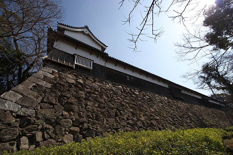
Photo: Wikimedia, CC BY-SA 3.0.
Fukuoka Castle is a Japanese castle located in Chūō-ku, Fukuoka, Japan. It is also known as Maizuru Castle or Seki Castle. Completed in the early Edo period for tozama daimyō Kuroda Nagamasa, it has been decreed a historic site by the Japanese government. Fukuoka Castle is situated 750 metres southwest of 福岡県福岡労働福祉事務所.
Chikae
Restaurant

Photo: Hirho, CC BY-SA 4.0.
Chikae is a restaurant, which is situated 210 metres east of 福岡県福岡労働福祉事務所.
Places in the Area
Nearby places include Tenjin and Ōhori Park.

Ōhori Park
Quarter

Photo: Tzuhsun Hsu, CC BY-SA 2.0.
Ōhori Park is a park in Chūō-ku, Fukuoka, Japan and a registered Place of Scenic Beauty.

福岡県福岡労働福祉事務所
- Type: Government office
- Categories: office and government building
- Location: Chūō-ku, Fukuoka, Fukuoka, Kyushu, Japan, East Asia, Asia
- View on OpenStreetMap
Latitude
33.58739° or 33° 35′ 15″ northLongitude
130.38986° or 130° 23′ 24″ eastOpen location code
8Q5GH9PQ+XWOpenStreetMap ID
node 1423781531OpenStreetMap feature
office=government
This page is based on OpenStreetMap, Wikidata, and Wikimedia Commons.
We’d love your help improving our open data sources. Thank you for contributing.
Satellite Map
Discover 福岡県福岡労働福祉事務所 from above in high-definition satellite imagery.
Notable Places Nearby
Highlights include 福岡中央公共職業安定所 and 高齢・障害者雇用支援機構福岡障害者職業センター.
Nearby Places
Explore places such as 九州電力 赤坂変電所 and 赤坂駐輪場(11).
Fukuoka: Must-Visit Destinations
Delve into Kitakyushu, Kurume, Dazaifu, and Nogata.
Curious Government Offices to Discover
Uncover intriguing government offices from every corner of the globe.
About Mapcarta. Data © OpenStreetMap contributors and available under the Open Database License". Text is available under the CC BY-SA 4.0 license, except for photos, directions, and the map. Photo: Krauser levyl, CC BY-SA 3.0.