福岡大学附属大濠中学校
福岡大学附属大濠中学校 is a school in Chūō-ku, Fukuoka, Fukuoka. 福岡大学附属大濠中学校 is situated nearby to the fountain 知識の泉, as well as near Fukuoka University Ohori High School.| Tap on a place to explore it |
Places of Interest Nearby
Highlights include Fukuoka Budōkan and Fukuoka Castle.
Fukuoka Budōkan
Sports venue

Photo: Miyuki Meinaka, CC BY-SA 3.0.
Fukuoka Budōkan is a sports venue, which is situated 110 metres northeast of 福岡大学附属大濠中学校.
Fukuoka Castle
Park
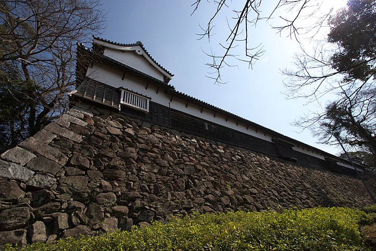
Photo: Wikimedia, CC BY-SA 3.0.
Fukuoka Castle is a Japanese castle located in Chūō-ku, Fukuoka, Japan. It is also known as Maizuru Castle or Seki Castle. Completed in the early Edo period for tozama daimyō Kuroda Nagamasa, it has been designated a National Historic Site of Japan in 1957. Fukuoka Castle is situated 590 metres northeast of 福岡大学附属大濠中学校.
Fukuoka-ken Gokoku-jinja
Shinto shrine

Photo: Wikimedia, CC BY-SA 2.0.
Fukuoka-ken Gokoku-jinja is a Shinto shrine, which is situated 390 metres east of 福岡大学附属大濠中学校.
Places in the Area
Nearby places include Ōhori Park and Jōnan-ku.
Ōhori Park
Quarter

Photo: Tzuhsun Hsu, CC BY-SA 2.0.
Ōhori Park is a park in Chūō-ku, Fukuoka, Japan and a registered Place of Scenic Beauty.
Jōnan-ku
Suburb

Photo: Muyo, CC BY-SA 3.0.
Jōnan-ku is one of the seven wards of Fukuoka City, Japan. As of November 1, 2004, it had a population of 128,057 people, making up 9.2% of Fukuoka City, with an area of 16.02 km2.

福岡大学附属大濠中学校
Latitude
33.5816° or 33° 34′ 54″ northLongitude
130.37724° or 130° 22′ 38″ eastOpen location code
8Q5GH9JG+JVOpenStreetMap ID
node 1423781869OpenStreetMap feature
amenity=schoolWikidata ID
Q94229481
This page is based on OpenStreetMap, Wikidata, and Wikimedia Commons.
We’d love your help improving our open data sources. Thank you for contributing.
Satellite Map
Discover 福岡大学附属大濠中学校 from above in high-definition satellite imagery.
In Other Languages
“福岡大学附属大濠中学校” goes by many names.
- Japanese: “福大大濠中学校”
- Japanese: “福岡大学附属大濠中”
- Japanese: “福岡大学附属大濠中学校”
- Japanese: “私立福岡大学附属大濠中学校”
Notable Places Nearby
Highlights include 知識の泉 and Fukuoka University Ohori High School.
Nearby Places
Explore places such as 西館 and Ohori Junior & Senior High School.
Fukuoka: Must-Visit Destinations
Delve into Kitakyushu, Kurume, Dazaifu, and Nogata.
Curious Schools to Discover
Uncover intriguing schools from every corner of the globe.
About Mapcarta. Data © OpenStreetMap contributors and available under the Open Database License". Text is available under the CC BY-SA 4.0 license, except for photos, directions, and the map. Photo: Krauser levyl, CC BY-SA 3.0.