中部船員地方労働委員会
中部船員地方労働委員会 is a government office in Naka Ward, Nagoya, Aichi. 中部船員地方労働委員会 is situated nearby to the government office 名古屋法務局, as well as near 名古屋合同庁舎第1号館.| Tap on a place to explore it |
Places of Interest Nearby
Highlights include Chubu District Transport Bureau and Aichi Prefectural Gymnasium.
Chubu District Transport Bureau
Government office

Photo: 円周率3パーセント, CC BY-SA 4.0.
Chubu District Transport Bureau is a government office.
Aichi Prefectural Gymnasium
Stadium

Photo: Wikimedia, CC BY-SA 3.0.
Aichi Prefectural Gymnasium, also known as Dolphins Arena, is a multi-purpose gymnasium in Nagoya, Japan, built in 1964. Aichi Prefectural Gymnasium is situated 260 metres north of 中部船員地方労働委員会.
Nagoya City Hall
Town hall

Photo: Alpsdake, CC BY-SA 3.0.
Nagoya City Hall is the city hall of the city of Nagoya, Japan. It is designed in the Imperial Crown style, a fusion Japanese and modern style. It survived the bombings of World War II and is registered as a Tangible Cultural Property of Japan. Nagoya City Hall is situated 300 metres east of 中部船員地方労働委員会.
Places in the Area
Nearby places include Nagoya Castle and Horibatacho.
Nagoya Castle
Locality
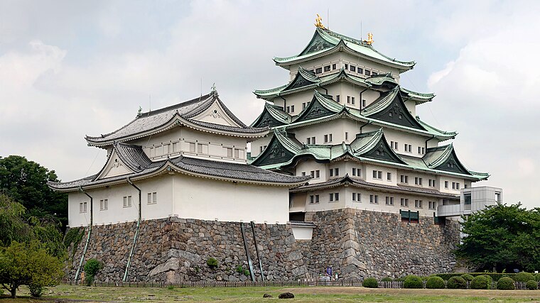
Photo: Base64, CC BY-SA 3.0.
Nagoya Castle is a Japanese castle located in Nagoya, Japan. Nagoya Castle was constructed by the Owari Domain in 1612 during the Edo period on the site of an earlier castle of the Oda clan in the Sengoku period.
Horibatacho
Quarter
Horibata-chō is a historic neighbourhood located in the Nishi ward of Nagoya, central Japan.
Nishiki 3-chome
Neighborhood

Photo: Akahito Yamabe, CC BY-SA 4.0.
Nishiki 3-chome is a neighborhood.
中部船員地方労働委員会
- Type: Government office
- Categories: office and government building
- Location: Naka Ward, Nagoya, Aichi, Chubu, Japan, East Asia, Asia
- View on OpenStreetMap
Latitude
35.18068° or 35° 10′ 51″ northLongitude
136.90324° or 136° 54′ 12″ eastOpen location code
8Q7R5WJ3+77OpenStreetMap ID
node 1423948548OpenStreetMap feature
office=government
This page is based on OpenStreetMap, Wikidata, and Wikimedia Commons.
We’d love your help improving our open data sources. Thank you for contributing.
Satellite Map
Discover 中部船員地方労働委員会 from above in high-definition satellite imagery.
Notable Places Nearby
Highlights include 名古屋法務局 and 名古屋合同庁舎第1号館.
Nearby Places
Explore places such as 中央新幹線工事ヤード and 中部経済産業局合同庁舎.
Aichi: Must-Visit Destinations
Delve into Toyota, Toyohashi, Okazaki, and Ichinomiya.
Curious Government Offices to Discover
Uncover intriguing government offices from every corner of the globe.
About Mapcarta. Data © OpenStreetMap contributors and available under the Open Database License". Text is available under the CC BY-SA 4.0 license, except for photos, directions, and the map. Photo: Wikimedia, CC BY 2.0.