昇樹会産科婦人科上野病院
昇樹会産科婦人科上野病院 is a hospital in Kita, Nagoya, Aichi. 昇樹会産科婦人科上野病院 is situated nearby to the restaurant Naohan, as well as near the fire station 名古屋市消防局北消防署飯田出張所.| Tap on a place to explore it |
Places of Interest Nearby
Highlights include Naohan and Heian-dōri Station.
Naohan
Restaurant

Photo: 円周率3パーセント, CC BY-SA 4.0.
Naohan is a restaurant, which is situated 150 metres northwest of 昇樹会産科婦人科上野病院.
Heian-dōri Station
Metro station

Photo: Hustvedt, CC BY-SA 3.0.
Heian-dōri Station is an underground interchange metro station located in Kita-ku, Nagoya, Aichi Prefecture, Japan, operated by the Transportation Bureau City of Nagoya. Heian-dōri Station is situated 440 metres north of 昇樹会産科婦人科上野病院.
Ōzone Station
Railway station

Photo: Asturio Cantabrio, CC BY-SA 4.0.
Ōzone Station is a railway station in Kita-ku, Nagoya, Aichi Prefecture, Japan. It is the largest transport hub in Northeastern Nagoya, connecting the JR Chuo Line, Meitetsu Seto Line, Meijo Subway Line, and Yutorito Nagoya guideway bus line. Ōzone Station is situated 770 metres east of 昇樹会産科婦人科上野病院.
Places in the Area
Nearby places include Higashi and Nagoya Castle.
Higashi
Suburb

Photo: Wikimedia, CC BY-SA 3.0.
Higashi Ward is one of the 16 wards of the city of Nagoya in Aichi Prefecture, Japan. As of 1 October 2011, the ward had an estimated population of 82,939 and a population density of 10,757 persons per km2. The total area was 7.71 km2.
Nagoya Castle
Locality
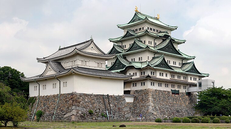
Photo: Base64, CC BY-SA 3.0.
Nagoya Castle is a Japanese castle located in Nagoya, Japan. Nagoya Castle was constructed by the Owari Domain in 1612 during the Edo period on the site of an earlier castle of the Oda clan in the Sengoku period. Nagoya Castle is situated 3 km west of 昇樹会産科婦人科上野病院.
Horibatacho
Quarter
Horibata-chō is a historic neighbourhood located in the Nishi ward of Nagoya, central Japan. Horibatacho is situated 3 km west of 昇樹会産科婦人科上野病院.
昇樹会産科婦人科上野病院
- Type: Hospital
- Category: health care
- Location: Kita, Nagoya, Aichi, Chubu, Japan, East Asia, Asia
- View on OpenStreetMap
Latitude
35.19192° or 35° 11′ 31″ northLongitude
136.92921° or 136° 55′ 45″ eastOpen location code
8Q7R5WRH+QMOpenStreetMap ID
node 1423987078OpenStreetMap feature
amenity=hospitalOpenStreetMap feature
healthcare=hospital
This page is based on OpenStreetMap, Wikidata, and Wikimedia Commons.
We’d love your help improving our open data sources. Thank you for contributing.
Satellite Map
Discover 昇樹会産科婦人科上野病院 from above in high-definition satellite imagery.
Notable Places Nearby
Highlights include 名古屋市消防局北消防署飯田出張所 and 六郷西公園.
Nearby Places
Explore places such as 西大曽根 and 喫茶ホープ.
Aichi: Must-Visit Destinations
Delve into Toyota, Toyohashi, Okazaki, and Ichinomiya.
Curious Places to Discover
Uncover intriguing places from every corner of the globe.
About Mapcarta. Data © OpenStreetMap contributors and available under the Open Database License". Text is available under the CC BY-SA 4.0 license, except for photos, directions, and the map. Photo: AndreCarrotflower, CC BY-SA 3.0.