Tesco
Tesco is a supermarket in Dublin, Leinster which is located on Kilmore Road. Tesco is situated nearby to Artane Post Office, as well as near the shopping center Artaine Castle Shopping Centre.| Tap on a place to explore it |
- Opening hours: 24/7
- Type: Supermarket
- Address: Kilmore Road, Dublin
- Wheelchair access: yes
Places of Interest Nearby
Highlights include Beaumont Hospital and Killester railway station.
Beaumont Hospital
Hospital
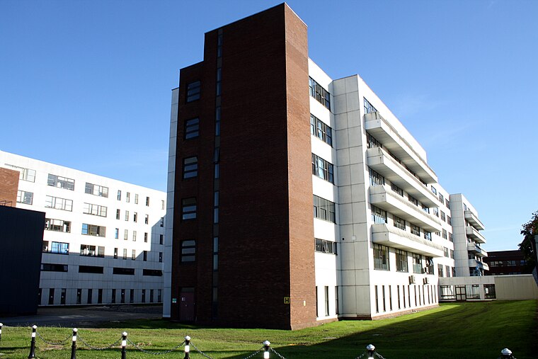
Photo: RavensFists, Public domain.
Beaumont Hospital is a large teaching hospital located in Beaumont, Dublin, Ireland. It is managed by RCSI Hospitals - one of the hospital groups established by the Health Service Executive. Beaumont Hospital is situated 1 km northwest of Tesco.
Killester railway station
Railway station

Photo: William Murphy, CC BY-SA 2.0.
Killester railway station serves the suburbs of Killester and Donnycarney, as well as parts of Artane, in Dublin. Killester railway station is situated 1¼ km southeast of Tesco.
Parnell Park
Stadium

Photo: Gnevin, Public domain.
Parnell Park is a GAA stadium in Donnycarney, Dublin, Ireland with a capacity of 7,300. It is the home of the Dublin GAA hurling, football, camogie and ladies' football teams at all levels of competition. Parnell Park is situated 1¼ km south of Tesco.
Places in the Area
Nearby places include Artane and Donnycarney.
Artane
Suburb

Photo: Raymond Okonski, CC BY-SA 2.0.
Artane, sometimes spelt Artaine, historically Tartaine is a northside suburb of Dublin city, Ireland. Artane is also a civil parish in the ancient barony of Coolock.
Donnycarney
Suburb

Photo: John Mianuyeu, CC BY-SA 2.0.
Donnycarney is a Northside suburb in the city of Dublin, Ireland, in the jurisdiction of Dublin City Council. It is mostly residential, around 5 kilometres from the centre of Dublin. Dublin GAA's home stadium, Parnell Park, is located here.
Coolock
Suburb

Photo: Rwxrwxrwx, CC BY-SA 3.0.
Coolock is a large suburban area, centred on a village, on Dublin city's Northside in Ireland. Coolock is crossed by the Santry River, a prominent feature in the middle of the district, with a linear park and ponds.
Tesco
- Categories: shop and food
- Location: Dublin, Leinster, Ireland, Britain and Ireland, Europe
- View on OpenStreetMap
Latitude
53.38325° or 53° 22′ 60″ northLongitude
-6.2151° or 6° 12′ 54″ westBrand
TescoOperator
Tesco IrelandOpen location code
9C5M9QMM+8XOpenStreetMap ID
node 1529996831OpenStreetMap feature
shop=supermarketOpenStreetMap attribute
wheelchair=yes
This page is based on OpenStreetMap, Wikidata, and Wikimedia Commons.
We’d love your help improving our open data sources. Thank you for contributing.
Satellite Map
Discover Tesco from above in high-definition satellite imagery.
Places with the Same Name
Discover other places named “Tesco”.
Notable Places Nearby
Highlights include Artaine Castle Shopping Centre and Artane Post Office.
Nearby Places
Explore places such as Penneys and Lifestyle.
Ireland: Must-Visit Destinations
Delve into Cork, Limerick, Galway, and Waterford.
Curious Supermarkets to Discover
Uncover intriguing supermarkets from every corner of the globe.
About Mapcarta. Data © OpenStreetMap contributors and available under the Open Database License". Text is available under the CC BY-SA 4.0 license, except for photos, directions, and the map. Photo: Wikimedia, CC0.