Lumskebugten
Lumskebugten is a restaurant located in a listed building at Esplanaden 21 in Copenhagen, Denmark. It has been owned by Erwin Lauterbach since 2011. With a history that goes back to 1854, it is one of the oldest restaurants in the city.| Tap on a place to explore it |
Photo: Royal Export, CC BY-SA 4.0.
- Opening hours:
Monday—Tuesday: 11:30 AM—3:00 PM
Wednesday—Saturday: 11:30 AM—3:00 PM and 5:30 PM—10:00 PM - Type: Restaurant
- Cuisine: regional
- Description: Danish restaurant
- Also known as: “Restaurant Lumskebuksen”
- Wheelchair access: yes
Places of Interest Nearby
Highlights include St Alban’s Anglican Church and Gefion Fountain.
St Alban’s Anglican Church
Church

Photo: Chris06, CC BY-SA 4.0.
St. Alban's Church, locally often referred to simply as the English Church, is an Anglican church in Copenhagen, Denmark. It was built from 1885 to 1887 for the benefit of the growing English congregation in the city. St Alban’s Anglican Church is situated 110 metres northwest of Lumskebugten.
Gefion Fountain

Photo: Jiří Komárek, CC BY-SA 4.0.
The Gefion Fountain is a large fountain on the harbour front in Copenhagen, Denmark. It features a large-scale group of oxen pulling a plow and being driven by the Norse goddess Gefjon. Gefion Fountain is situated 100 metres north of Lumskebugten.
Amalienborg
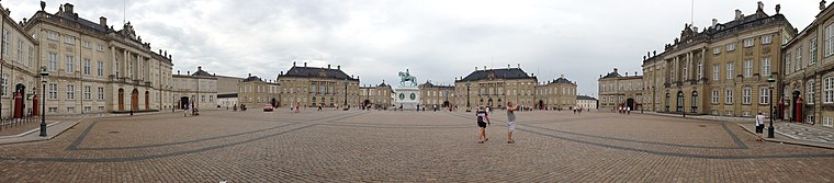
Photo: Janeway666, CC BY-SA 3.0.
Amalienborg is the official residence for the Danish royal family and is located in Copenhagen. Frederick VIII's palace complex has four identical Classical façades, effectively four palaces, with Rococo interiors, laid around an octagonal courtyard. Amalienborg is situated 580 metres southwest of Lumskebugten.
Places in the Area
Nearby places include Frederiksstaden and Nyboder.
Frederiksstaden
Quarter

Photo: Manscher, CC BY-SA 3.0.
Frederiksstaden is a district in Copenhagen, Denmark. Constructed during the reign of Frederick V in the second half of the 18th century, it is considered to be one of the most important rococo complexes in Europe and was included in the 2006 Danish Culture Canon.
Nyboder
Quarter

Photo: Wikimedia, CC BY-SA 3.0.
Nyboder is a historic row house district of former Naval barracks in Copenhagen, Denmark. It was planned and first built by Christian IV to accommodate a need for housing for the personnel of the rapidly growing Royal Danish Navy and their families during that time.
Indre By
Indre By is the central area and the historical heart of Copenhagen, bounded by the lakes circling the inner city and the harbour, it reflects the entire city’s extent during the reign of King Christian IV, when the town was fortified.Lumskebugten
- Category: food
- Location: Copenhagen municipality, Capital Region, Denmark, Nordic countries, Europe
- View on OpenStreetMap
Latitude
55.68839° or 55° 41′ 18″ northLongitude
12.59801° or 12° 35′ 53″ eastOpen location code
9F7JMHQX+96OpenStreetMap ID
node 1538103622OpenStreetMap feature
amenity=restaurantOpenStreetMap attribute
cuisine=regionalOpenStreetMap attribute
wheelchair=yesWikidata ID
Q23869156
This page is based on OpenStreetMap, Wikidata, Wikimedia Commons, and Wikipedia.
We’d love your help improving our open data sources. Thank you for contributing.
Satellite Map
Discover Lumskebugten from above in high-definition satellite imagery.
In Other Languages
From Danish to Turkish—“Lumskebugten” goes by many names.
- Danish: “Lumskebugten”
- Danish: “Restaurant Lumskebugten”
- Danish: “Restaurant Lumskebuksen”
- German: “Restaurant Lumskebuksen”
- Norwegian Bokmål: “Restaurant Lumskebuksen”
- Turkish: “Restaurant Lumskebuksen”
Places with the Same Name
Discover other places named “Lumskebugten”.
Notable Places Nearby
Highlights include Havnebygmesterens Studiesamling and Toldbodens Bådehavn.
Nearby Places
Explore places such as Visitationsbygningen and Søkortarkivet.
Denmark: Must-Visit Destinations
Delve into Copenhagen, Aarhus, Odense, and Aalborg.
Curious Restaurants to Discover
Uncover intriguing restaurants from every corner of the globe.
About Mapcarta. Data © OpenStreetMap contributors and available under the Open Database License". Text is available under the CC BY-SA 4.0 license, except for photos, directions, and the map. Description text is based on the Wikipedia page “Lumskebugten”. Photo: Royal Export, CC BY-SA 4.0.