Wien Fasangasse
Wien Fasangasse is a tram stop in Landstraße, Vienna. Wien Fasangasse is situated nearby to Tanzschule Eddy Franzen, as well as near the work of art Chopin Monument ‘La Note Bleue’.| Tap on a place to explore it |
Photo: Herzi Pinki, CC BY-SA 4.0.
Places of Interest Nearby
Highlights include Belvedere and Wien Hauptbahnhof.
Belvedere
Park
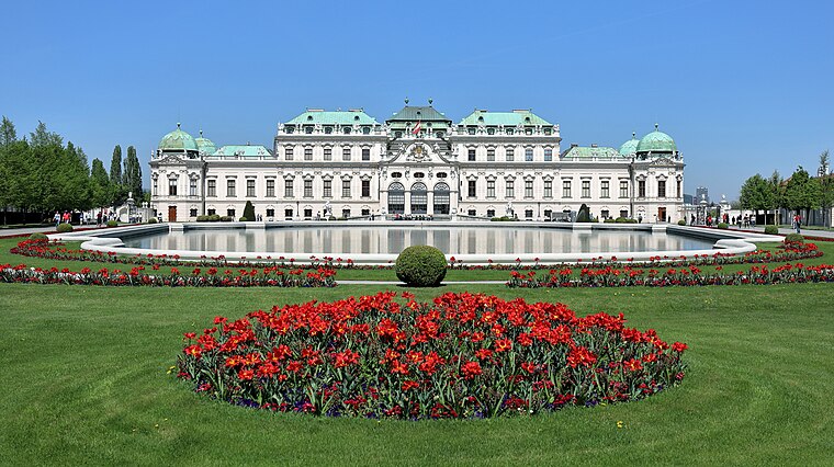
Photo: Bwag, CC BY-SA 4.0.
The Belvedere is a historic building complex in Vienna, Austria consisting of two Baroque palaces, the Orangery, and the Palace Stables. The buildings are set in a Baroque park landscape in the third district of the city, on the south-eastern edge of its centre. Belvedere is situated 670 metres northwest of Wien Fasangasse.
Wien Hauptbahnhof
Railway station

Photo: Eweht, CC BY-SA 4.0.
Wien Hauptbahnhof, Vienna Central Station or Vienna Main Station is the main railway station in Vienna, Austria, located in the Favoriten district. It became fully operational in December 2015, linking major railway lines from the north, east, south and west, and replacing the old Wien Südbahnhof terminus. Wien Hauptbahnhof is situated 660 metres southwest of Wien Fasangasse.
Belvedere 21
Museum

Photo: Bwag, CC BY-SA 4.0.
Belvedere 21, formerly 21er Haus or Einundzwanziger Haus, is a modernist style steel and glass building designed by Austrian architect Karl Schwanzer. Originally constructed as the Austrian pavilion or temporary showroom for the Expo 58 in Brussels, it was later transferred to Vienna to house the Museum of the 20th Century, which explains why it was first nicknamed "20er Haus". Belvedere 21 is situated 300 metres southwest of Wien Fasangasse.
Places in the Area
Nearby places include Fasanviertel and Quartier Belvedere.


Vienna Arsenal
Neighborhood

Photo: Deneb, Public domain.
The Arsenal is a former military complex of buildings in the south-east of Vienna in the third district. Several brick buildings in a rectangle layout make up the complex which is located on a bank south of the Landstraßer Gürtel.
Wien Fasangasse
- Type: Tram stop
- Wheelchair access: yes
- Categories: railway stop, transport stop, and transportation
- Location: Landstraße, Vienna, Austria, Central Europe, Europe
- View on OpenStreetMap
Latitude
48.18826° or 48° 11′ 18″ northLongitude
16.38545° or 16° 23′ 8″ eastOperator
Wiener LinienNetwork
Verkehrsverbund Ost-RegionOpen location code
8FWR59QP+85OpenStreetMap ID
node 1625876626OpenStreetMap feature
public_transport=stop_positionOpenStreetMap feature
railway=tram_stopOpenStreetMap attribute
wheelchair=yesWikidata ID
Q132177022
This page is based on OpenStreetMap, Wikidata, and Wikimedia Commons.
We’d love your help improving our open data sources. Thank you for contributing.
Satellite Map
Discover Wien Fasangasse from above in high-definition satellite imagery.
In Other Languages
From French to German—“Wien Fasangasse” goes by many names.
- French: “Fasangasse”
- German: “Wien Fasangasse”
Notable Places Nearby
Highlights include Tanzschule Eddy Franzen and Chopin Monument ‘La Note Bleue’.
Nearby Places
Explore places such as Blumen B&B and Fasangasse.
Vienna: Must-Visit Destinations
Delve into Innere Stadt, Vienna International Airport, Inner East, and Hietzing.
Curious Tram Stops to Discover
Uncover intriguing tram stops from every corner of the globe.
About Mapcarta. Data © OpenStreetMap contributors and available under the Open Database License". Text is available under the CC BY-SA 4.0 license, except for photos, directions, and the map. Photo: Herzi Pinki, CC BY-SA 4.0.