Feuchtgebiet am Aubach
Feuchtgebiet am Aubach is in Frickingen, Bodenseekreis, Baden-Württemberg. Feuchtgebiet am Aubach is situated nearby to the pitch Tennisclub Frickingen - Altheim - Lippertsreute, as well as near Spielvereinigung Frickingen-Altheim-Lippertsreute.| Tap on a place to explore it |
Places of Interest Nearby
Highlights include St. Pankratius and Unsere Liebe Frau.
St. Pankratius
Church

Photo: Aristeas, CC BY-SA 4.0.
St. Pankratius is a church, which is situated 1¼ km north of Feuchtgebiet am Aubach.
Unsere Liebe Frau
Church

Photo: Zollernalb, CC BY-SA 4.0.
Unsere Liebe Frau is a church, which is situated 2 km southwest of Feuchtgebiet am Aubach.
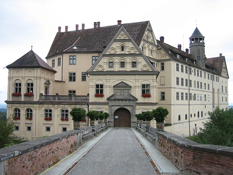
Schloss Heiligenberg

Photo: Carsten Steger, CC BY-SA 4.0.
Heiligenberg Castle is a princely castle in renaissance style, situated in Heiligenberg, Linzgau within the state of Baden-Württemberg, Germany. The castle is owned and lived in by the Berk Canpasoglou de Fürstenberg's family, and cannot be visited. Schloss Heiligenberg is situated 4 km east of Feuchtgebiet am Aubach.
Places in the Area
Nearby places include Lippertsreute and Hohenbodman.

Hohenbodman
Village
Hohenbodman is a village in the municipality of Owingen in the western Bodenseekreis in Baden-Württemberg, Germany. Hohenbodman is situated 4 km west of Feuchtgebiet am Aubach.
Heiligenberg
Village
 Heiligenberg is a municipality and a village in the Bodensee district in Baden-Württemberg, about seven kilometres north of Salem, in Germany. Heiligenberg is situated 4 km east of Feuchtgebiet am Aubach.
Feuchtgebiet am Aubach
- Type: Sign
- Categories: information and tourism
- Location: Frickingen, Bodenseekreis, Tübingen Region, Baden-Württemberg, Germany, Central Europe, Europe
- View on OpenStreetMap
Latitude
47.81586° or 47° 48′ 57″ northLongitude
9.25928° or 9° 15′ 33″ eastOpen location code
8FVFR785+8POpenStreetMap ID
node 1647312649OpenStreetMap feature
tourism=information
This page is based on OpenStreetMap, Wikidata, and Wikimedia Commons.
We’d love your help improving our open data sources. Thank you for contributing.
Satellite Map
Discover Feuchtgebiet am Aubach from above in high-definition satellite imagery.
Notable Places Nearby
Highlights include Feuchtgebiet am Aubach and Tennisclub Frickingen - Altheim - Lippertsreute.
Nearby Places
Explore places such as Gärtnerei Hodapp and AUBACH restaurant sportsbar.
Baden-Württemberg: Must-Visit Destinations
Delve into Stuttgart, Heidelberg, Karlsruhe, and Mannheim.
Curious Places to Discover
Uncover intriguing places from every corner of the globe.
About Mapcarta. Data © OpenStreetMap contributors and available under the Open Database License". Text is available under the CC BY-SA 4.0 license, except for photos, directions, and the map. Photo: Traveler100, CC BY-SA 3.0.