Die Reichsbahn
Die Reichsbahn is a memorial in Aachen, Cologne District, North Rhine-Westphalia. Die Reichsbahn is situated nearby to the tourism office DB Reisezentrum, as well as near the railway station Aachen Hauptbahnhof.| Tap on a place to explore it |
Places of Interest Nearby
Highlights include Aachen Hauptbahnhof and Haus Grenzwacht.
Aachen Hauptbahnhof
Railway station
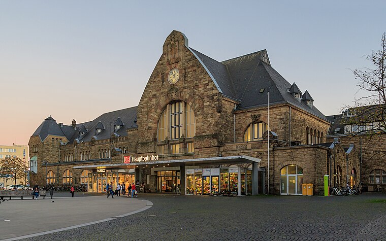 Aachen Hauptbahnhof is the most important railway station for the city of Aachen, in the far west of Germany near the Dutch and Belgian border. It is the largest of the four currently active Aachen stations, and is integrated into the long-distance network.
Haus Grenzwacht
Public building

Photo: Grunpfnul, CC BY-SA 4.0.
Haus Grenzwacht is a public building.
Aachen Cathedral
Church

Photo: Cccefalon, CC BY-SA 3.0.
Aachen Cathedral is a Catholic church in Aachen, Germany and the cathedral of the Diocese of Aachen. One of the oldest cathedral buildings in Europe, it was constructed as the royal chapel of the Palace of Aachen of Emperor Charlemagne, who was buried there in 814. Aachen Cathedral is situated 1 km northwest of Die Reichsbahn.
Places in the Area
Nearby places include Burtscheid and Kaiserplatz.
Burtscheid
Suburb

Photo: ArthurMcGill, CC BY-SA 4.0.
Burtscheid is a district of the city of Aachen, part of the Aachen-Mitte Stadtbezirk. It is a health resort.


Die Reichsbahn
- Type: Memorial
- Inscription: “Für viele Menschen war ab 1933 der Aachener Hauptbahnhof die letzte deutsche Station auf ihrer Flucht vor der nationalsozialistischen Verfolgung. Sie flohen nach Belgien, nach Frankreich, nach Großbritannien, in die Niederlande, in die USA, nach Palästina”
- Category: historic site
- Location: Aachen, Aachen, Cologne District, Eifel, North Rhine-Westphalia, Germany, Central Europe, Europe
- View on OpenStreetMap
Latitude
50.76834° or 50° 46′ 6″ northLongitude
6.0911° or 6° 5′ 28″ eastNetwork
Wege gegen das VergessenOpen location code
9F28Q39R+8COpenStreetMap ID
node 1659336874OpenStreetMap feature
historic=memorial
This page is based on OpenStreetMap, Wikidata, and Wikimedia Commons.
We’d love your help improving our open data sources. Thank you for contributing.
Satellite Map
Discover Die Reichsbahn from above in high-definition satellite imagery.
Notable Places Nearby
Highlights include DB Reisezentrum and Bahnhofplatz.
Nearby Places
Explore places such as Press P&B Books and go.Center.
Eifel: Must-Visit Destinations
Delve into Monschau, Herzogenrath, Zülpich, and Bad Münstereifel.
Curious Memorials to Discover
Uncover intriguing memorials from every corner of the globe.
About Mapcarta. Data © OpenStreetMap contributors and available under the Open Database License". Text is available under the CC BY-SA 4.0 license, except for photos, directions, and the map. Photo: Knipptang, CC BY-SA 3.0.