empire;Adler
empire;Adler is a shop in Edingen-Neckarhausen, Rhein-Neckar-Kreis, Baden-Württemberg. empire;Adler is situated nearby to the shopping center eec - Edingen-Neckarhäuser Einkaufscenter, as well as near the sports venue Krîfon - Schule für Historische Fechtkunst.| Tap on a place to explore it |
Places of Interest Nearby
Highlights include Neu-Edingen/Mannheim-Friedrichsfeld station and Schloss Neckarhausen.
Neu-Edingen/Mannheim-Friedrichsfeld station
Railway station
Neu-Edingen/Mannheim-Friedrichsfeld station is a separation station in the Mannheim district of Friedrichsfeld on the border with the municipality of Edingen-Neckarhausen in the German state of Baden-Württemberg. Neu-Edingen/Mannheim-Friedrichsfeld station is situated 770 metres southwest of empire;Adler.
Schloss Neckarhausen
Town hall
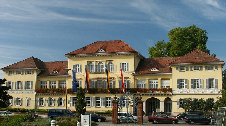
Photo: 2micha, CC BY-SA 3.0.
Schloss Neckarhausen is a town hall, which is situated 1½ km northeast of empire;Adler.
Neckaraue zwischen Botzheimer Wasen und Obere Wörth
Nature reserve

Photo: mroszewski, CC BY-SA 3.0.
Neckaraue zwischen Botzheimer Wasen und Obere Wörth is a nature reserve.
Places in the Area
Nearby places include Ladenburg and Ilvesheim.
Ladenburg
 The small town of Ladenburg is on the Neckar, near Heidelberg, and is part of the federal state of Baden-Württemberg.
Ilvesheim
Village

Photo: Randy43, Public domain.
Ilvesheim is a municipality of about 9,300 residents in the district of Rhein-Neckar in Baden-Württemberg in Germany. It is one of the first towns located along the famous Bertha Benz Memorial Route. Ilvesheim is situated 2½ km northwest of empire;Adler.
Neubotzheim
Hamlet

Photo: Immanuel Giel, Public domain.
Neubotzheim is a hamlet, which is situated 3 km east of empire;Adler.
empire;Adler
- Type: Shop
- Category: post office
- Location: Edingen-Neckarhausen, Rhein-Neckar-Kreis, Karlsruhe Region, Baden-Württemberg, Germany, Central Europe, Europe
- View on OpenStreetMap
Latitude
49.45328° or 49° 27′ 12″ northLongitude
8.58827° or 8° 35′ 18″ eastOpen location code
8FXCFH3Q+88OpenStreetMap ID
node 1835676522OpenStreetMap feature
amenity=post_officeOpenStreetMap feature
shop=videoOpenStreetMap feature
shop=clothes
This page is based on OpenStreetMap, Wikidata, and Wikimedia Commons.
We’d love your help improving our open data sources. Thank you for contributing.
Satellite Map
Discover empire;Adler from above in high-definition satellite imagery.
Notable Places Nearby
Highlights include eec - Edingen-Neckarhäuser Einkaufscenter and Krîfon - Schule für Historische Fechtkunst.
Nearby Places
Explore places such as Balikaya and Bäcker Görtz.
Baden-Württemberg: Must-Visit Destinations
Delve into Stuttgart, Heidelberg, Karlsruhe, and Mannheim.
Curious Shops to Discover
Uncover intriguing shops from every corner of the globe.
About Mapcarta. Data © OpenStreetMap contributors and available under the Open Database License". Text is available under the CC BY-SA 4.0 license, except for photos, directions, and the map. Photo: Traveler100, CC BY-SA 3.0.