Adelheidisstraße
Adelheidisstraße is a tram stop in Bonn, Cologne District, North Rhine-Westphalia. Adelheidisstraße is situated nearby to the church Haus der Gemeinde, as well as near the government office Bundeszentralamt für Steuern.| Tap on a place to explore it |
- Type: Tram stop
- Description: railway station in Bonn, Germany
- Wheelchair access: yes
Places of Interest Nearby
Highlights include Doppelkirche Schwarzrheindorf and Burg Lede.
Doppelkirche Schwarzrheindorf
Church

Photo: Wikimedia, CC BY-SA 3.0.
The Doppelkirche Schwarzrheindorf is a Romanesque church in Bonn, North Rhine-Westphalia, Germany. The church was once part of a Benedictine nunnery located at Schwarzrheindorf, now part of Bonn. Doppelkirche Schwarzrheindorf is situated 1 km northwest of Adelheidisstraße.
Burg Lede
Castle

Photo: StefanServos, CC BY-SA 3.0.
Burg Lede is a castle, which is situated 800 metres north of Adelheidisstraße.
St. Peter
Church
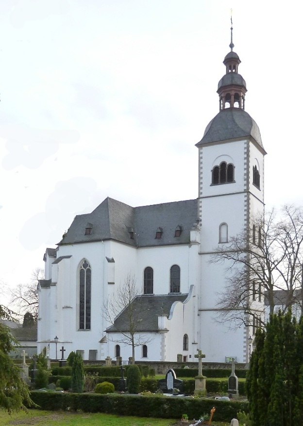
Photo: Leonce49, CC BY-SA 3.0 de.
St. Peter is a church, which is situated 620 metres north of Adelheidisstraße.
Places in the Area
Nearby places include Beuel and Pützchen-Bechlinghoven.
Beuel
Suburb

Photo: AKirch-Bonn, CC BY-SA 4.0.
Beuel is a city borough of Bonn, Germany. It has a population of 67,827.

Holzlar
Quarter
Holzlar Is an enclosed settlement in Bonn's district Beuel, east of the Rhine and north of the Siebengebirge in Germany. Holzlar has a population of about 11,000 and consists out of the former villages Holzlar, Kohlkaul, Heidebergen, Roleber and Gielgen. Holzlar is situated 3 km east of Adelheidisstraße.
Adelheidisstraße
- Categories: railway station, station, and transportation
- Location: Bonn, Cologne District, Cologne Lowland, North Rhine-Westphalia, Germany, Central Europe, Europe
- View on OpenStreetMap
Latitude
50.74766° or 50° 44′ 52″ northLongitude
7.12574° or 7° 7′ 33″ eastOpen location code
9F29P4XG+37OpenStreetMap ID
node 1887366588OpenStreetMap feature
public_transport=stationOpenStreetMap feature
railway=tram_stopOpenStreetMap attribute
wheelchair=yesWikidata ID
Q20035708
This page is based on OpenStreetMap, Wikidata, and Wikimedia Commons.
We’d love your help improving our open data sources. Thank you for contributing.
Satellite Map
Discover Adelheidisstraße from above in high-definition satellite imagery.
In Other Languages
From French to German—“Adelheidisstraße” goes by many names.
- French: “Adelheidisstraße”
- German: “Adelheidisstraße”
Notable Places Nearby
Highlights include Haus der Gemeinde and Bundeszentralamt für Steuern.
Nearby Places
Explore places such as Adelheidisstraße and Adelheidisstraße.
Cologne Lowland: Must-Visit Destinations
Delve into Cologne, Leverkusen, Siegburg, and Bad Honnef.
Curious Tram Stops to Discover
Uncover intriguing tram stops from every corner of the globe.
About Mapcarta. Data © OpenStreetMap contributors and available under the Open Database License". Text is available under the CC BY-SA 4.0 license, except for photos, directions, and the map. Photo: Qualle, CC BY 2.5.