Hochbehälter Bensheim
Hochbehälter Bensheim is a reservoir in Bensheim, Bergstraße, Hesse. Hochbehälter Bensheim is situated nearby to the locality Im kleinen Viehtrieb, as well as near In der Kalkgasse Winteseite.| Tap on a place to explore it |
Places of Interest
Highlights include Auerbach Castle and Bensheim station.
Auerbach Castle

Photo: Daribbah76, CC BY-SA 4.0.
Auerbach Castle is one of several fortresses along the Bergstrasse in southern Hesse, Germany. The castle was originally built by King Charlemagne and rebuilt by Count Diether IV of the Katzenelnbogen dynasty in the second quarter of the 13th century.
Bensheim station
Railway station
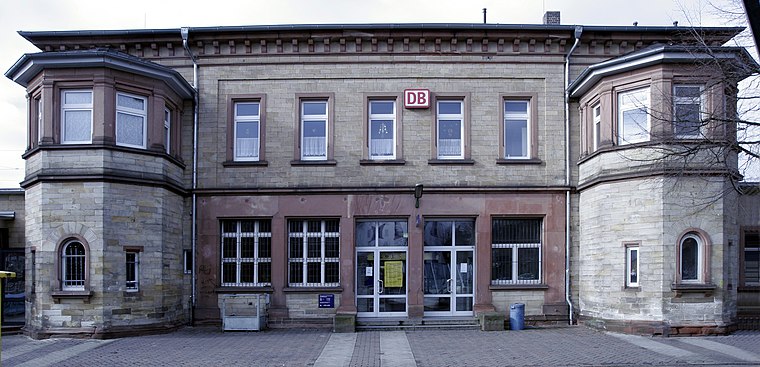
Photo: Wikimedia, CC BY-SA 3.0.
Bensheim station is in the town of Bensheim on the Main-Neckar Railway, connecting Frankfurt and Heidelberg, in the German state of Hesse. The station is also the beginning and end of the single-track non-electrified Worms–Bensheim line.
Kirchberg
Peak

Photo: Wikimedia, CC BY-SA 3.0 de.
Kirchberg is a hill located near Bensheim in Hesse, Germany. It stands at an elevation of approximately 220.6 meters. The hill is renowned for its vineyards, particularly those producing Riesling wines, contributing to the region's reputation in viticulture.
Places in the Area
Nearby places include Heppenheim and Lorsch.
Heppenheim

Photo: Berthold Werner, CC BY-SA 3.0.
Heppenheim is a town in South Hesse, Germany along the Bergstraße, a mountain road running on the western edge of the Odenwald mountain range.
Lorsch

Photo: Kuebi, CC BY-SA 3.0.
Lorsch is a town in the Bergstraße district in Hessen, Germany, 60 km south of Frankfurt. Lorsch is well known for the Lorsch Abbey, which has been named a World Heritage Site by UNESCO.

Hochbehälter Bensheim
- Type: Reservoir
- Category: body of water
- Location: Bensheim, Bergstraße, South Hesse, Hesse, Germany, Central Europe, Europe
- View on OpenStreetMap
Latitude
49.6946° or 49° 41′ 41″ northLongitude
8.6381° or 8° 38′ 17″ eastInception
1966Open location code
8FXCMJVQ+R6OpenStreetMap ID
node 2046979910OpenStreetMap feature
man_made=reservoir_covered
This page is based on OpenStreetMap, Wikidata, and Wikimedia Commons.
We’d love your help improving our open data sources. Thank you for contributing.
Satellite Map
Discover Hochbehälter Bensheim from above in high-definition satellite imagery.
Localities in the Area
Explore places such as Im kleinen Viehtrieb and In der Kalkgasse Winteseite.
Notable Places Nearby
Highlights include SV Schönberg Hartplatz and SV Schönberg Vereinsheim.
South Hesse: Must-Visit Destinations
Delve into Darmstadt, Lorsch, Heppenheim, and Dreieich.
Curious Reservoirs to Discover
Uncover intriguing reservoirs from every corner of the globe.
About Mapcarta. Data © OpenStreetMap contributors and available under the Open Database License". Text is available under the CC BY-SA 4.0 license, except for photos, directions, and the map. Photo: Kesslerbensheim, CC BY-SA 4.0.