PR-24 (C. Wilson) & PR-888 (Av. Las Nereidas)
PR-24 (C. Wilson) & PR-888 (Av. Las Nereidas) is a bus stop in Cataño barrio-pueblo, Cataño. PR-24 (C. Wilson) & PR-888 (Av. Las Nereidas) is situated nearby to the pier Puente de Orgullo, as well as near the park Plaza del Recreo de Cataño.| Tap on a place to explore it |
Places of Interest Nearby
Highlights include Fort San Felipe del Morro and Fernando Luis Ribas Dominicci Airport.
Fort San Felipe del Morro
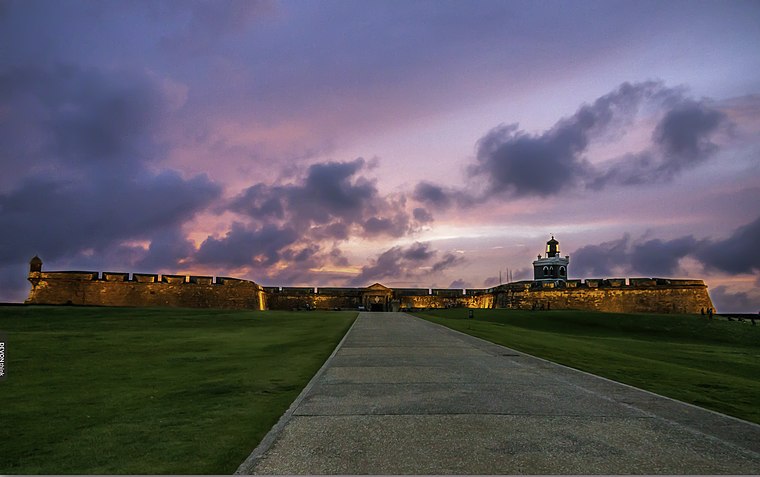
Photo: Madera, CC BY-SA 3.0.
Castillo San Felipe del Morro, most commonly known as El Morro, is a large fortress and citadel in the Old San Juan historic quarter of San Juan, the capital municipality of Puerto Rico. Fort San Felipe del Morro is situated 3½ km north of PR-24 (C. Wilson) & PR-888 (Av. Las Nereidas).
Fernando Luis Ribas Dominicci Airport
Aerodrome

Photo: Jonathan Palombo, CC BY 2.0.
Fernando Luis Ribas Dominicci Airport, commonly known as Isla Grande Airport is a small airport in Puerto Rico serving the capital municipality of San Juan and its metropolitan area since 1929. Fernando Luis Ribas Dominicci Airport is situated 2½ km northeast of PR-24 (C. Wilson) & PR-888 (Av. Las Nereidas).
San Cathedral Basilica of Saint John the Baptist
Church
 The Metropolitan Cathedral Basilica of Saint John the Baptist, officially known as the Minor Basilica of Saint John the Baptist and Parish of Our Lady of Remedies, is the Catholic cathedral for the Archdiocese of San Juan de Puerto Rico. San Cathedral Basilica of Saint John the Baptist is situated 2½ km north of PR-24 (C. Wilson) & PR-888 (Av. Las Nereidas).
Places in the Area
Nearby places include San Juan and San Juan.
San Juan

Photo: Tomás Fano, CC BY-SA 2.0.
San Juan is the capital of Puerto Rico and its largest city, with 342,000 inhabitants in the municipality and 2,203,000 in the metropolitan area. Founded in 1521 by the Spanish conquistadors, San Juan is the oldest city under the jurisdiction of the United States.
San Juan
Quarter

Photo: Wikimedia, Public domain.
Old San Juan is a historic district located at the "northwest triangle" of the islet of San Juan in San Juan. Its area roughly correlates to the Ballajá, Catedral, Marina, Mercado, San Cristóbal, and San Francisco sub-barrios of barrio San Juan Antiguo in the municipality of San Juan, Puerto Rico. San Juan is situated 2½ km north of PR-24 (C. Wilson) & PR-888 (Av. Las Nereidas).
La Perla
Neighborhood

Photo: Wikimedia, CC BY-SA 3.0.
La Perla is a historic neighborhood located in the northern historic city of Old San Juan, Puerto Rico, stretching about 650 yards along the rocky Atlantic coast immediately east of the Santa Maria Magdalena de Pazzis Cemetery and down the slope from Calle Norzagaray. La Perla is situated 3 km north of PR-24 (C. Wilson) & PR-888 (Av. Las Nereidas).
PR-24 (C. Wilson) & PR-888 (Av. Las Nereidas)
- Type: Bus stop
- Category: transportation
- Location: Cataño barrio-pueblo, Cataño, Northern Coast, Puerto Rico, Caribbean, North America
- View on OpenStreetMap
Latitude
18.44173° or 18° 26′ 30″ northLongitude
-66.11841° or 66° 7′ 6″ westOperator
Autoridad Metropolitana de AutobusesOpen location code
77CMCVRJ+MJOpenStreetMap ID
node 2057195311OpenStreetMap feature
highway=bus_stopOpenStreetMap feature
public_transport=platform
This page is based on OpenStreetMap, Wikidata, and Wikimedia Commons.
We’d love your help improving our open data sources. Thank you for contributing.
Satellite Map
Discover PR-24 (C. Wilson) & PR-888 (Av. Las Nereidas) from above in high-definition satellite imagery.
Notable Places Nearby
Highlights include Puente de Orgullo and Plaza del Recreo de Cataño.
Nearby Places
Explore places such as Gulf and Gulf Express.
Northern Coast: Must-Visit Destinations
Delve into San Juan, Arecibo, Bayamón, and Carolina.
Curious Bus Stops to Discover
Uncover intriguing bus stops from every corner of the globe.
About Mapcarta. Data © OpenStreetMap contributors and available under the Open Database License". Text is available under the CC BY-SA 4.0 license, except for photos, directions, and the map. Photo: Jeff Hitchcock, CC BY 2.0.