Aussichtspunkt Südpark
Aussichtspunkt Südpark is a scenic viewpoint in Merseburg, Saalekreis, Saxony-Anhalt. Aussichtspunkt Südpark is situated nearby to the pitch Labyrinth, as well as near Damwild.| Tap on a place to explore it |
Places of Interest Nearby
Highlights include Deutsches Chemie-Museum Merseburg and Planetarium Merseburg.
Deutsches Chemie-Museum Merseburg
Park

Photo: Reinhard Ferdinand, CC0.
Deutsches Chemie-Museum Merseburg is a park, which is situated 1 km west of Aussichtspunkt Südpark.
Planetarium Merseburg
Planetarium

Photo: Wikimedia, CC BY-SA 3.0 de.
Planetarium Merseburg is situated 1½ km north of Aussichtspunkt Südpark.
Merseburg Hauptbahnhof
Railway station
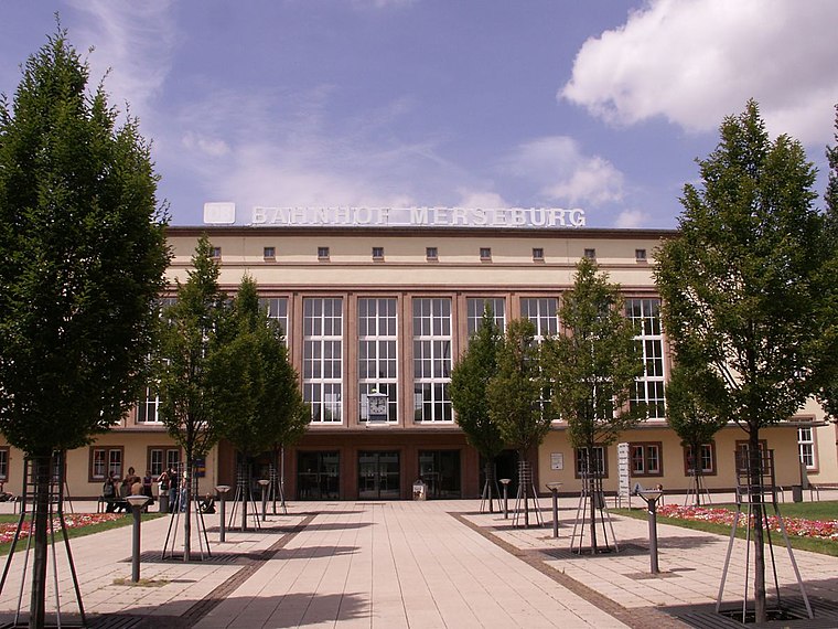 Merseburg Hauptbahnhof is the main station of the town of Merseburg in the German state of Saxony-Anhalt. It is located on the Halle–Bebra railway and Deutsche Bahn assigns it to category 4. Merseburg Hauptbahnhof is situated 2 km north of Aussichtspunkt Südpark.
Places in the Area
Nearby places include Atzendorf and Beuna.

Beuna
Village
Beuna is a village and a former municipality in the Saalekreis district, in Saxony-Anhalt, Germany. Since 1 January 2009, it is part of the town Merseburg. Beuna is situated 3 km southwest of Aussichtspunkt Südpark.
Geusa
Village

Photo: Jwaller, CC BY-SA 4.0.
Geusa is a village and a former municipality within the district Saalekreis, in the federal state of Saxony-Anhalt, Germany. Since January 1, 2010, it is within the town limits of Merseburg. Geusa is situated 3 km west of Aussichtspunkt Südpark.
Aussichtspunkt Südpark
- Type: Scenic viewpoint
- Category: tourism
- Location: Merseburg, Saalekreis, Saxony-Anhalt, Germany, Central Europe, Europe
- View on OpenStreetMap
Latitude
51.34052° or 51° 20′ 26″ northLongitude
11.98561° or 11° 59′ 8″ eastOpen location code
9F3H8XRP+66OpenStreetMap ID
node 2085757937OpenStreetMap feature
tourism=viewpoint
This page is based on OpenStreetMap, Wikidata, and Wikimedia Commons.
We’d love your help improving our open data sources. Thank you for contributing.
Satellite Map
Discover Aussichtspunkt Südpark from above in high-definition satellite imagery.
Notable Places Nearby
Highlights include Labyrinth and Damwild.
Nearby Places
Explore places such as Südpark-Tierpark and Merseburg Süd, Häuerstraße.
Saxony-Anhalt: Must-Visit Destinations
Delve into Magdeburg, Halle, Wittenberg, and Quedlinburg.
Curious Scenic Viewpoints to Discover
Uncover intriguing scenic viewpoints from every corner of the globe.
About Mapcarta. Data © OpenStreetMap contributors and available under the Open Database License". Text is available under the CC BY-SA 4.0 license, except for photos, directions, and the map. Photo: Hoger, CC BY-SA 3.0 de.