Ginthans Street Food
Ginthans Street Food is a fast food restaurant in Aachen, Cologne District, North Rhine-Westphalia which is located on Lothringerstraße. Ginthans Street Food is situated nearby to the memorial Stolperstein dedicated to Rosa Marx, as well as near Stolperstein dedicated to Else Marx.| Tap on a place to explore it |
- Opening hours:
Monday—Saturday: 11:00 AM—3:00 PM and 6:00 PM—10:00 PM
Sunday and public holidays: closed - Type: Fast food restaurant
- Cuisine: Indian, international, burger, sausage, pizza, pasta, sandwich, and salad
- Address: Lothringerstraße 7
- Wheelchair access: no
Places of Interest Nearby
Highlights include Aachen Cathedral and Suermondt-Ludwig-Museum.
Aachen Cathedral
Church

Photo: Cccefalon, CC BY-SA 3.0.
Aachen Cathedral is a Catholic church in Aachen, Germany and the cathedral of the Diocese of Aachen. One of the oldest cathedral buildings in Europe, it was constructed as the royal chapel of the Palace of Aachen of Emperor Charlemagne, who was buried there in 814. Aachen Cathedral is situated 730 metres northwest of Ginthans Street Food.
Suermondt-Ludwig-Museum
Museum

Photo: Hdamm, CC BY-SA 3.0.
The Suermondt-Ludwig-Museum is an art museum in Aachen, Germany. Founded in 1877, its collection includes works by Aelbrecht Bouts, Joos van Cleve, Anthony van Dyck, Otto Dix and Max Beckmann. Suermondt-Ludwig-Museum is situated 260 metres northeast of Ginthans Street Food.
Aachen Hauptbahnhof
Railway station
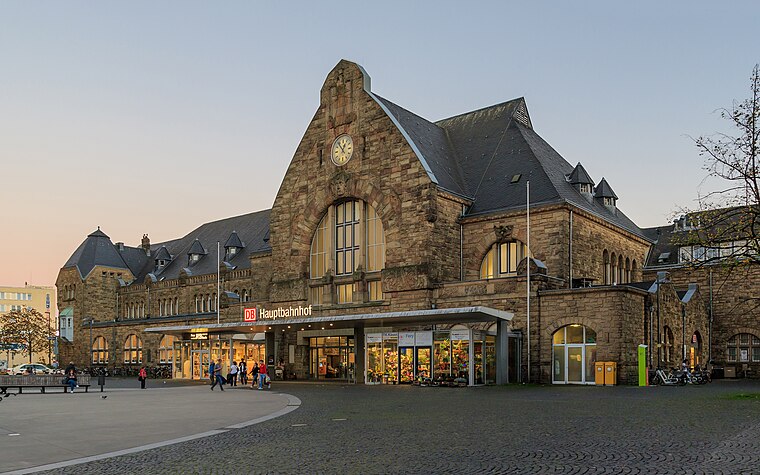 Aachen Hauptbahnhof is the most important railway station for the city of Aachen, in the far west of Germany near the Dutch and Belgian border. It is the largest of the four currently active Aachen stations, and is integrated into the long-distance network. Aachen Hauptbahnhof is situated 440 metres south of Ginthans Street Food.
Places in the Area
Nearby places include Kaiserplatz and Burtscheid.

Burtscheid
Suburb

Photo: ArthurMcGill, CC BY-SA 4.0.
Burtscheid is a district of the city of Aachen, part of the Aachen-Mitte Stadtbezirk. It is a health resort.

Ginthans Street Food
- Categories: food and restaurant
- Location: Aachen, Aachen, Cologne District, Eifel, North Rhine-Westphalia, Germany, Central Europe, Europe
- View on OpenStreetMap
Latitude
50.7716° or 50° 46′ 18″ northLongitude
6.09312° or 6° 5′ 35″ eastOpen location code
9F28Q3CV+J6OpenStreetMap ID
node 2239768217OpenStreetMap feature
amenity=fast_foodOpenStreetMap attribute
cuisine=indianOpenStreetMap attribute
cuisine=internationalOpenStreetMap attribute
cuisine=burgerOpenStreetMap attribute
cuisine=sausageOpenStreetMap attribute
cuisine=pizzaOpenStreetMap attribute
cuisine=pastaOpenStreetMap attribute
cuisine=sandwichOpenStreetMap attribute
cuisine=saladOpenStreetMap attribute
wheelchair=no
This page is based on OpenStreetMap, Wikidata, and Wikimedia Commons.
We’d love your help improving our open data sources. Thank you for contributing.
Satellite Map
Discover Ginthans Street Food from above in high-definition satellite imagery.
Notable Places Nearby
Highlights include Stolperstein dedicated to Joseph Marx and Stolperstein dedicated to Rosa Marx.
Nearby Places
Explore places such as Zahnarztpraxis Belladent and Thai Sabay.
Eifel: Must-Visit Destinations
Delve into Monschau, Herzogenrath, Zülpich, and Bad Münstereifel.
Curious Fast Food Restaurants to Discover
Uncover intriguing fast food restaurants from every corner of the globe.
About Mapcarta. Data © OpenStreetMap contributors and available under the Open Database License". Text is available under the CC BY-SA 4.0 license, except for photos, directions, and the map. Photo: Knipptang, CC BY-SA 3.0.