Liberty Island
Liberty Island is a transport stop in Manhattan, New York. Liberty Island is situated nearby to the recreation area Cafe Plaza, as well as near Statue of Liberty Museum.| Tap on a place to explore it |
Places of Interest Nearby
Highlights include Statue of Liberty and Statue of Liberty Museum.
Statue of Liberty
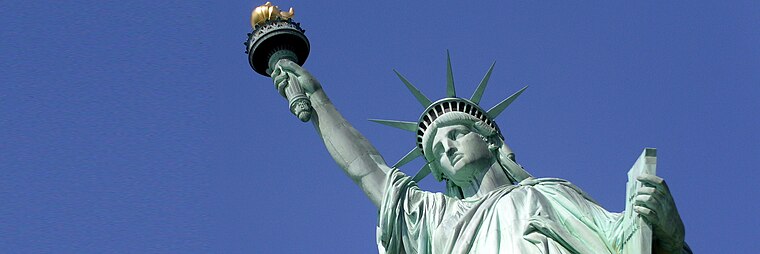 The Statue of Liberty is a colossal neoclassical sculpture of a robed and crowned woman on Liberty Island in New York Harbor, within New York City, U.S. Statue of Liberty is situated 890 feet east of Liberty Island.
Statue of Liberty Museum
Museum

Photo: Epicgenius, CC BY-SA 4.0.
The Statue of Liberty Museum is located on Liberty Island in New York City. The museum opened on May 16, 2019, and is focused on the creation, meaning, and history of the Statue of Liberty, a large statue by Frédéric Auguste Bartholdi which the people of France gave to the people of the United States in 1886. Statue of Liberty Museum is situated 510 feet northeast of Liberty Island.
Ellis Island
Islet

Photo: Wikimedia, Public domain.
Ellis Island is an island in New York Harbor, within the U.S. states of New Jersey and New York. Owned by the U.S. government, Ellis Island was once the busiest immigrant inspection and processing station in the United States.
Places in the Area
Nearby places include Communipaw and Battery Park City.
Communipaw
Village

Photo: Semiautonomous, CC BY-SA 4.0.
Communipaw is a neighborhood in Jersey City in Hudson County, in the U.S. state of New Jersey. It is located west of Liberty State Park and east of Bergen Hill, and the site of one of the earliest European settlements in North America.
Battery Park City
Neighborhood

Photo: Gryffindor, CC BY-SA 3.0.
Battery Park City is a neighborhood and planned community at the southern tip of Manhattan in New York City. The neighborhood is situated along the Hudson River waterfront, and separated the Financial District and Tribeca by the West Side Highway. Battery Park City is situated 2 miles northeast of Liberty Island.
Jersey City

Photo: King of Hearts, CC BY-SA 4.0.
Jersey City is New Jersey's second-largest city. Jersey City sits in Hudson County in the northeastern section of the state, across the Hudson from its older and bigger cousin, New York City and south of Hoboken.
Liberty Island
- Type: Transport stop
- Wheelchair access: limited
- Categories: passenger ship terminal and transportation
- Location: Manhattan, New York, Mid-Atlantic, United States, North America
- View on OpenStreetMap
Latitude
40.68985° or 40° 41′ 24″ northLongitude
-74.04767° or 74° 2′ 52″ westOpen location code
87G7MXQ2+WWOpenStreetMap ID
node 2311190720OpenStreetMap feature
amenity=ferry_terminalOpenStreetMap feature
public_transport=stop_positionOpenStreetMap attribute
wheelchair=limited
This page is based on OpenStreetMap, Wikidata, and Wikimedia Commons.
We’d love your help improving our open data sources. Thank you for contributing.
Satellite Map
Discover Liberty Island from above in high-definition satellite imagery.
In Other Languages
From Arabic to Ukrainian—“Liberty Island” goes by many names.
- Arabic: “جزيرة الحرية”
- Belarusian: “Востраў Свабоды”
- Lithuanian: “Laisvės sala”
- Portuguese: “Ilha da Liberdade”
- Russian: “Остров Свободы”
- Serbian: “Острво Слободе”
- Spanish: “Isla de la Libertad”
- Ukrainian: “Острів Свободи”
Places with the Same Name
Discover other places named “Liberty Island”.
Notable Places Nearby
Highlights include Cafe Plaza and Liberty Island Information Center.
Nearby Places
Explore places such as Generator Building and Audio Tour Pavilion.
Manhattan: Must-Visit Destinations
Delve into Central Park, Upper East Side, Theater District, and Upper West Side.
Curious Transport Stops to Discover
Uncover intriguing transport stops from every corner of the globe.
About Mapcarta. Data © OpenStreetMap contributors and available under the Open Database License". Text is available under the CC BY-SA 4.0 license, except for photos, directions, and the map. Photo: Wikimedia, CC BY-SA 3.0.