Urbanización Antares
Urbanización Antares is a neighborhood in Santo Domingo Este (Zona Urbana), Santo Domingo Province. Urbanización Antares is situated nearby to the neighborhood Brisas del Mar, as well as near Residencial Acuario.| Tap on a place to explore it |
Places of Interest
Highlights include Los Tres Ojos National Park and Fortaleza Ozama.
Los Tres Ojos National Park
Cave

Photo: Swatigsood, Public domain.
The Three Eyes National Park is a 50-yard open-air limestone cave located in Mirador del Este park, within the Santo Domingo Este municipality of the Dominican Republic.
Fortaleza Ozama
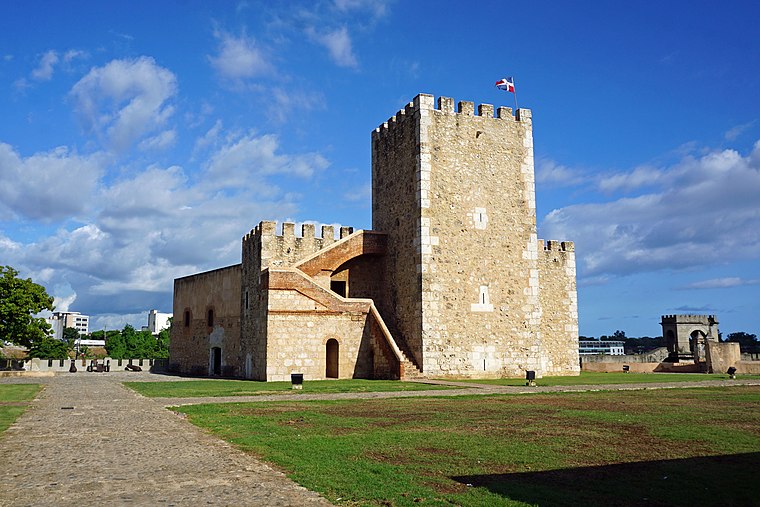
Photo: Mariordo, CC BY-SA 4.0.
The Ozama Fortress, also formerly known as the city wall's Homage tower, is one of the surviving sections of the Walls of Santo Domingo, which is recognized by UNESCO as being the oldest military construction of European origin in the Americas. Fortaleza Ozama is situated 3½ km west of Urbanización Antares.
Places in the Area
Nearby places include Los Mameyes and Ciudad Colonial.
Los Mameyes
Neighborhood
Los Mameyes is a neighbourhood in the city of Santo Domingo Este in the province of Santo Domingo of the Dominican Republic. This neighbourhood is populated in particular by individuals from the middle classes.
Ciudad Colonial
Village

Photo: Mariordo, CC BY-SA 4.0.
Ciudad Colonial is the historic central neighborhood of the Dominican Republic's capital Santo Domingo. It is the oldest continuously inhabited European-established settlement in the Americas. Ciudad Colonial is situated 4 km west of Urbanización Antares.
Santo Domingo

Photo: Melvin feliz12, CC BY-SA 3.0.
Santo Domingo is the capital of the Dominican Republic, the oldest European city in the Americas, and the most developed city on the island of Hispaniola.
Urbanización Antares
- Type: Neighborhood
- Category: locality
- Location: Santo Domingo Este (Zona Urbana), Santo Domingo Este, Santo Domingo Province, Dominican Republic, Caribbean, North America
- View on OpenStreetMap
Latitude
18.47205° or 18° 28′ 19″ northLongitude
-69.84946° or 69° 50′ 58″ westOpen location code
77CGF5C2+R6OpenStreetMap ID
node 2372609323OpenStreetMap feature
place=neighbourhood
This page is based on OpenStreetMap, Wikidata, and Wikimedia Commons.
We’d love your help improving our open data sources. Thank you for contributing.
Satellite Map
Discover Urbanización Antares from above in high-definition satellite imagery.
Places with the Same Name
Discover other places named “Urbanización Antares”.
Localities in the Area
Explore places such as Brisas del Mar and Residencial Acuario.
Notable Places Nearby
Highlights include Iglesia Evangélica De La Revelación and Coronel Rafael Emilio Peña.
Dominican Republic: Must-Visit Destinations
Delve into Santo Domingo, Santiago de los Caballeros, Punta Cana, and Puerto Plata.
Curious Neighborhoods to Discover
Uncover intriguing neighborhoods from every corner of the globe.
About Mapcarta. Data © OpenStreetMap contributors and available under the Open Database License". Text is available under the CC BY-SA 4.0 license, except for photos, directions, and the map. Photo: It419, CC BY-SA 3.0.