Hafen Damgarten
Hafen Damgarten is a marina in Ribnitz-Damgarten, Landkreis Vorpommern-Rügen, Mecklenburg-Western Pomerania. Hafen Damgarten is situated nearby to Kanu-Verleih, as well as near the town hall Rathaus Damgarten.| Tap on a place to explore it |
Places of Interest Nearby
Highlights include Saint Bartholomew Church and Ribnitz-Damgarten Ost railway station.
Saint Bartholomew Church
Church

Photo: Erell, CC BY-SA 3.0.
Saint Bartholomew Church is situated 420 metres north of Hafen Damgarten.
Ribnitz-Damgarten Ost railway station
Railway station
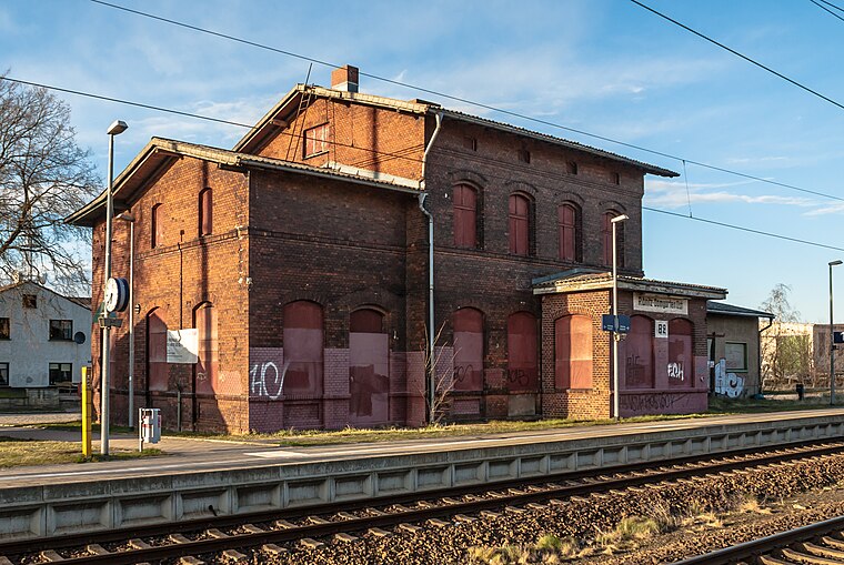
Photo: Wikimedia, CC BY-SA 4.0.
Ribnitz-Damgarten Ost railway station is situated 1 km east of Hafen Damgarten.
Richard-Wossidlo-Gymnasium
School

Photo: Rimshot, CC BY-SA 2.5.
Richard-Wossidlo-Gymnasium is a school, which is situated 560 metres northeast of Hafen Damgarten.
Places in the Area
Nearby places include Damgarten and Putnitz.


Ribnitz-Damgarten
Town

Photo: DorisAntony, CC BY-SA 3.0.
Ribnitz-Damgarten is a town in Mecklenburg-Vorpommern, Germany, situated on Lake Ribnitz. Ribnitz-Damgarten is in the west of the district Vorpommern-Rügen. Ribnitz-Damgarten is situated 2½ km west of Hafen Damgarten.
Hafen Damgarten
- Type: Marina
- Categories: recreation area and transportation
- Location: Ribnitz-Damgarten, Landkreis Vorpommern-Rügen, Mecklenburg-Western Pomerania, Germany, Central Europe, Europe
- View on OpenStreetMap
Latitude
54.25072° or 54° 15′ 3″ northLongitude
12.47116° or 12° 28′ 16″ eastOpen location code
9F6J7F2C+7FOpenStreetMap ID
node 2394811816OpenStreetMap feature
leisure=marina
This page is based on OpenStreetMap, Wikidata, and Wikimedia Commons.
We’d love your help improving our open data sources. Thank you for contributing.
Satellite Map
Discover Hafen Damgarten from above in high-definition satellite imagery.
Notable Places Nearby
Highlights include Kanu-Verleih and Rathaus Damgarten.
Nearby Places
Explore places such as Ronnys Gaststätte Anglerheim and Fischverkauf & Imbiss.
Mecklenburg-Western Pomerania: Must-Visit Destinations
Delve into Schwerin, Rostock, Wismar, and Stralsund.
Curious Marinas to Discover
Uncover intriguing marinas from every corner of the globe.
About Mapcarta. Data © OpenStreetMap contributors and available under the Open Database License". Text is available under the CC BY-SA 4.0 license, except for photos, directions, and the map. Photo: Schiwago, CC BY 2.5.