KENJI TAKI GALLERY
KENJI TAKI GALLERY is a museum in Naka Ward, Nagoya, Aichi. KENJI TAKI GALLERY is situated nearby to the museum ギャラリー顕美子, as well as near ギャラリー聚.| Tap on a place to explore it |
Places of Interest Nearby
Highlights include Nagoya City Art Museum and Nagoya City Science Museum.
Nagoya City Art Museum
Museum

Photo: Oilstreet, CC BY-SA 3.0.
The Nagoya City Art Museum is located in the city of Nagoya in central Japan. The museum building itself was constructed by Kisho Kurokawa, one of the leading Japanese architects, from 1983 to 1987. Nagoya City Art Museum is situated 220 metres southwest of KENJI TAKI GALLERY.
Nagoya City Science Museum
Museum

Photo: 名古屋太郎, CC BY-SA 3.0.
The Nagoya City Science Museum is a museum located in Sakae, Nagoya, the center of Nagoya City, in central Japan. The museum houses one of the largest planetariums in the world and has three main sections on modern technology, life sciences and general science with a variety of hands-on exhibits. Nagoya City Science Museum is situated 270 metres west of KENJI TAKI GALLERY.
Shuko-ji Temple (Nagoya)
Buddhist temple

Photo: Asturio Cantabrio, CC BY-SA 4.0.
Shuko-ji Temple (Nagoya) is a Buddhist temple.
Places in the Area
Nearby places include Nishiki 3-chome and Nagoya Castle.
Nishiki 3-chome
Neighborhood

Photo: Akahito Yamabe, CC BY-SA 4.0.
Nishiki 3-chome is a neighborhood.
Nagoya Castle
Locality
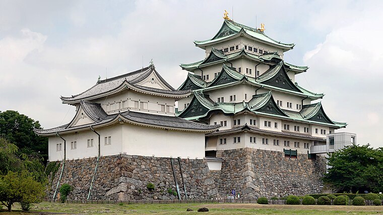
Photo: Base64, CC BY-SA 3.0.
Nagoya Castle is a Japanese castle located in Nagoya, Japan. Nagoya Castle was constructed by the Owari Domain in 1612 during the Edo period on the site of an earlier castle of the Oda clan in the Sengoku period.
Horibatacho
Quarter
Horibata-chō is a historic neighbourhood located in the Nishi ward of Nagoya, central Japan. Horibatacho is situated 2½ km north of KENJI TAKI GALLERY.
KENJI TAKI GALLERY
Latitude
35.16514° or 35° 9′ 55″ northLongitude
136.90268° or 136° 54′ 10″ eastOpen location code
8Q7R5W83+33OpenStreetMap ID
node 2401055655OpenStreetMap feature
tourism=museum
This page is based on OpenStreetMap, Wikidata, and Wikimedia Commons.
We’d love your help improving our open data sources. Thank you for contributing.
Satellite Map
Discover KENJI TAKI GALLERY from above in high-definition satellite imagery.
Notable Places Nearby
Highlights include ギャラリー顕美子 and ギャラリー聚.
Nearby Places
Explore places such as Mitsui Repark and The Meat Angus.
Aichi: Must-Visit Destinations
Delve into Toyota, Toyohashi, Okazaki, and Ichinomiya.
Curious Museums to Discover
Uncover intriguing museums from every corner of the globe.
About Mapcarta. Data © OpenStreetMap contributors and available under the Open Database License". Text is available under the CC BY-SA 4.0 license, except for photos, directions, and the map. Photo: Wikimedia, CC BY 2.0.