Gendarmerie nationale
Gendarmerie nationale is a police station in Saint-Brevin-les-Pins, Arrondissement of Saint-Nazaire, Pays de la Loire. Gendarmerie nationale is situated nearby to the military installation Caserne Marcel Bouhard, as well as near the cemetery Military Square.| Tap on a place to explore it |
- Opening hours:
Monday—Saturday: 8:00 AM—noon and 2:00 PM—6:00 PM
Sunday: 9:00 AM—noon and 3:00 PM—6:00 PM
public holidays: 9:00 AM—noon and 3:00 PM—6:00 PM - Type: Police station
- Also known as: “Gendarmerie - Brigade de Saint-Brevin-les-Pins”
Places of Interest Nearby
Highlights include La Briordais dolmen and Le Plessis-Gamat menhir.
La Briordais dolmen
Archaeological site

Photo: Poulpy, CC BY-SA 3.0.
La Briordais dolmen is an archaeological site, which is situated 1 km east of Gendarmerie nationale.
Le Plessis-Gamat menhir
Archaeological site

Photo: Selbymay, CC BY-SA 3.0.
Le Plessis-Gamat menhir is an archaeological site, which is situated 1¼ km north of Gendarmerie nationale.
Les Rossignols dolmen
Archaeological site
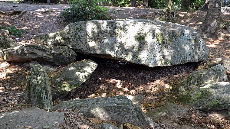
Photo: Selbymay, CC BY-SA 3.0.
Les Rossignols dolmen is an archaeological site, which is situated 1½ km southwest of Gendarmerie nationale.
Places in the Area
Nearby places include Saint-Brevin-les-Pins and Saint-Nazaire.
Saint-Brevin-les-Pins
Village

Photo: JYB Devot, CC BY-SA 4.0.
Saint-Brevin-les-Pins is a commune in the Loire-Atlantique department in western France. It is known as the site of the serpent d'océan, a giant sea serpent sculpture by artist Huang Yong Ping.
Saint-Nazaire

Photo: TouN, CC BY-SA 3.0.
Saint-Nazaire is a port town of 153,000 people at the mouth of the Loire, near Nantes in western France.
Saint-Michel-Chef-Chef
Village

Photo: Zeisterre, CC BY-SA 3.0.
Saint-Michel-Chef-Chef is a commune in the Loire-Atlantique department in western France. Its inhabitants, known as Michelois, numbered 5,173 at the 2018 census. Saint-Michel-Chef-Chef is situated 7 km south of Gendarmerie nationale.
Gendarmerie nationale
Latitude
47.24514° or 47° 14′ 43″ northLongitude
-2.15601° or 2° 9′ 22″ westOperator
National GendarmerieOpen location code
8CVV6RWV+3HOpenStreetMap ID
node 2417009859OpenStreetMap feature
amenity=police
This page is based on OpenStreetMap, Wikidata, and Wikimedia Commons.
We’d love your help improving our open data sources. Thank you for contributing.
Satellite Map
Discover Gendarmerie nationale from above in high-definition satellite imagery.
In Other Languages
“Gendarmerie nationale” goes by many names.
- Breton: “Archeriezh vroadel”
Places with the Same Name
Discover other places named “Gendarmerie nationale”.
Notable Places Nearby
Highlights include Caserne Marcel Bouhard and Military Square.
Nearby Places
Explore places such as Chez Victor et Louise and Médipole.
Pays de la Loire: Must-Visit Destinations
Delve into Montsoreau, Nantes, Angers, and Le Mans.
Curious Police Stations to Discover
Uncover intriguing police stations from every corner of the globe.
About Mapcarta. Data © OpenStreetMap contributors and available under the Open Database License". Text is available under the CC BY-SA 4.0 license, except for photos, directions, and the map. Photo: DakoR, CC BY-SA 3.0.