Lower Erebus Hut
The Lower Erebus Hut is a permanent field facility located on Mount Erebus on Ross Island, Antarctica. The hut served as the seasonal base of the Mount Erebus Volcano Observatory, run by New Mexico Institute of Mining and Technology.| Tap on a place to explore it |
Photo: Jirhiker, Public domain.
Places of Interest Nearby
Highlights include Mount Erebus and Crystal Slope.
Mount Erebus
Volcano
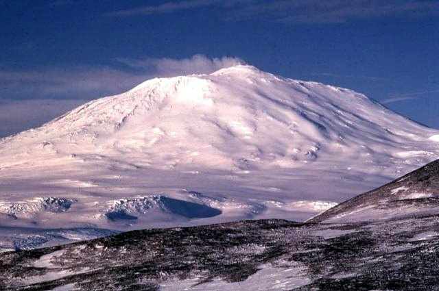
Photo: Wikimedia, Public domain.
Mount Erebus is the southernmost active volcano on Earth, located on Ross Island in the Ross Dependency in Antarctica. With a summit elevation of 3,792 metres, it is the second most prominent mountain in Antarctica and the second-highest volcano in Antarctica.
Crystal Slope
Peak
Mount Erebus is the southernmost active volcano on Earth, located on Ross Island in the Ross Dependency in Antarctica. With a summit elevation of 3,792 metres, it is the second most prominent mountain in Antarctica and the second-highest volcano in Antarctica.
Camp Slope
Peak
Mount Erebus is the southernmost active volcano on Earth, located on Ross Island in the Ross Dependency in Antarctica. With a summit elevation of 3,792 metres, it is the second most prominent mountain in Antarctica and the second-highest volcano in Antarctica.
Places in the Area
Nearby places include Nausea Knob.
Nausea Knob
Locality
Mount Erebus is the southernmost active volcano on Earth, located on Ross Island in the Ross Dependency in Antarctica. With a summit elevation of 3,792 metres, it is the second most prominent mountain in Antarctica and the second-highest volcano in Antarctica.
Lower Erebus Hut
- Type: Mountain hut
- Description: antarctic base in the United States
- Categories: Antarctic research station, building, tourism, and accommodation
- Location: Antarctica
- View on OpenStreetMap
Latitude
-77.51044° or 77° 30′ 38″ southLongitude
167.14661° or 167° 8′ 48″ eastOperator
United StatesOpen location code
2VJ9F4QW+RJOpenStreetMap ID
node 2418868701OpenStreetMap feature
building=yesOpenStreetMap feature
tourism=alpine_hutWikidata ID
Q3264383
This page is based on OpenStreetMap, Wikidata, Wikimedia Commons, and Wikipedia.
We’d love your help improving our open data sources. Thank you for contributing.
Satellite Map
Discover Lower Erebus Hut from above in high-definition satellite imagery.
In Other Languages
From French to Spanish—“Lower Erebus Hut” goes by many names.
- French: “Lower Erebus Hut”
- Norwegian Nynorsk: “Lower Erebus Hut”
- Spanish: “Refugio Erebus Inferior”
Notable Places Nearby
Highlights include Eastern Cone and Western Crater.
Nearby Places
Explore places such as Lower Fang and Mount Erebus Crash Memorial Cross.
Antarctica: Must-Visit Destinations
Delve into Livingston Island, Villa Las Estrellas, South Pole, and Antarctic Peninsula.
Curious Mountain Huts to Discover
Uncover intriguing mountain huts from every corner of the globe.
About Mapcarta. Data © OpenStreetMap contributors and available under the Open Database License". Text is available under the CC BY-SA 4.0 license, except for photos, directions, and the map. Description text is based on the Wikipedia page “Lower Erebus Hut”. Photo: Jirhiker, Public domain.