Johann Facinelli
Johann Facinelli is a memorial in Salzburg, Salzburg. Johann Facinelli is situated nearby to the playground Spielplatz Rupertgasse, as well as near the health club Kieser Training.| Tap on a place to explore it |
Places of Interest Nearby
Highlights include Mozarteum University and Fortress Hohensalzburg.
Mozarteum University
University
 Mozarteum University Salzburg is one of three affiliated but separate entities under the "Mozarteum" name in Salzburg municipality; the International Mozarteum Foundation and the Mozarteum Orchestra Salzburg are the other two. Mozarteum University is situated 1 km southwest of Johann Facinelli.
Fortress Hohensalzburg
Castle
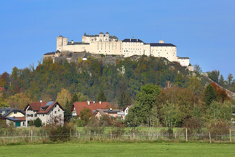
Photo: Bwag, CC BY-SA 4.0.
Hohensalzburg Fortress is a large medieval fortress in the city of Salzburg, Austria. It sits atop the Festungsberg mountain at an altitude of 506 m. It was erected at the behest of the prince-archbishops of Salzburg. Fortress Hohensalzburg is situated 1½ km south of Johann Facinelli.
Synagogue in Salzburg
Synagogue

Photo: Wikimedia, CC BY-SA 3.0.
Synagogue in Salzburg is situated 240 metres west of Johann Facinelli.
Places in the Area
Nearby places include Kapuzinerberg and Nonnberg.
Kapuzinerberg
Locality

Photo: Eweht, CC BY-SA 3.0.
Kapuzinerberg is a hill on the eastern bank of the Salzach river in the city of Salzburg in Austria, which rises to an elevation of 640 metres. It is located to the north of Salzburg's historic city centre, and forms part of the city's UNESCO World Heritage Site.


Johann Facinelli
- Type: Memorial
- Category: historic site
- Location: Salzburg, Salzburg, Austria, Central Europe, Europe
- View on OpenStreetMap
Latitude
47.80762° or 47° 48′ 27″ northLongitude
13.05345° or 13° 3′ 12″ eastNetwork
Stolpersteine SalzburgOpen location code
8FVMR353+29OpenStreetMap ID
node 2532171723OpenStreetMap feature
historic=memorial
This page is based on OpenStreetMap, Wikidata, and Wikimedia Commons.
We’d love your help improving our open data sources. Thank you for contributing.
Satellite Map
Discover Johann Facinelli from above in high-definition satellite imagery.
Notable Places Nearby
Highlights include Spielplatz Rupertgasse and Kieser Training.
Nearby Places
Explore places such as Bergland Hotel and Jedermann.
Salzburg: Must-Visit Destinations
Delve into Bischofshofen, Bad Gastein, Zell am See, and St. Johann im Pongau.
Curious Memorials to Discover
Uncover intriguing memorials from every corner of the globe.
About Mapcarta. Data © OpenStreetMap contributors and available under the Open Database License". Text is available under the CC BY-SA 4.0 license, except for photos, directions, and the map. Photo: Wikimedia, CC BY-SA 3.0.