Grapillon des Merles
Grapillon des Merles is a peak in Peisey-Nancroix, Arrondissement of Albertville, Auvergne-Rhône-Alpes and has an elevation of 2,784 metres. Grapillon des Merles is situated nearby to the locality Beau Plan, as well as near Montée de la Tourne.| Tap on a place to explore it |
Places of Interest
Highlights include Lac de Tignes and Rochers Rouges.
Lac de Tignes
Lake
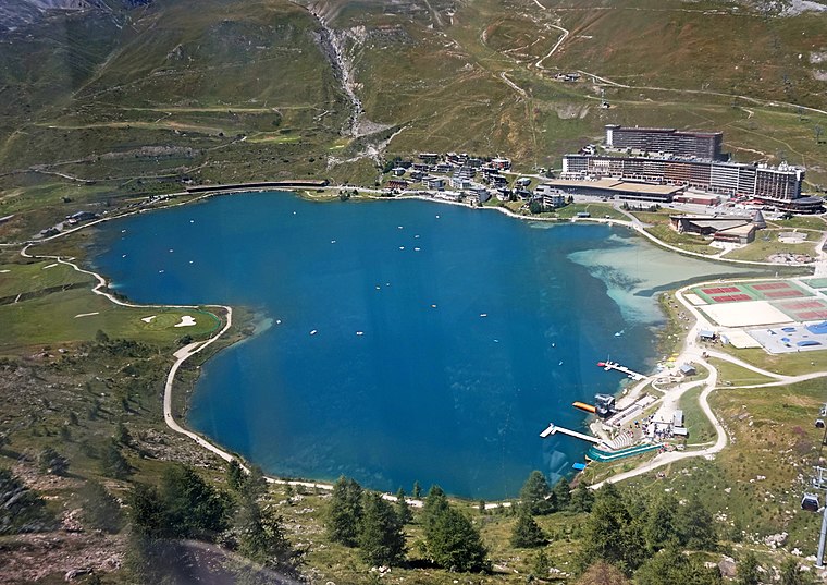
Photo: Kulmalukko, CC BY-SA 3.0.
Lac de Tignes is a lake at Tignes in the Savoie department of France.

Dôme des Platières
Peak

Photo: Wikimedia, CC BY-SA 4.0.
Dôme des Platières is a mountain of Savoie, France. It lies in the Massif de la Vanoise range. It has an elevation of 3,473 metres above sea level.
Places in the Area
Nearby places include Tignes.
Tignes
 Tignes is a famous resort in the French Alps linked to Val D'Isere. Tignes is a winter resort for skiing, and a summer one for hiking, mountain biking, and summer skiing on the glacier.
Grapillon des Merles
- Type: Peak with an elevation of 2,784 metres
- Also known as: “Aiguille du Fond de la Tourne”
- Category: landform
- Location: Peisey-Nancroix, Arrondissement of Albertville, Savoie, Auvergne-Rhône-Alpes, France, Europe
- View on OpenStreetMap
Latitude
45.4743° or 45° 28′ 28″ northLongitude
6.8727° or 6° 52′ 22″ eastElevation
2,784 metres (9,134 feet)Open location code
8FQ8FVFF+P3OpenStreetMap ID
node 2548567090OpenStreetMap feature
natural=peak
This page is based on OpenStreetMap, Wikidata, and Wikimedia Commons.
We’d love your help improving our open data sources. Thank you for contributing.
Satellite Map
Discover Grapillon des Merles from above in high-definition satellite imagery.
Localities in the Area
Explore places such as Beau Plan and Montée de la Tourne.
Notable Places Nearby
Highlights include Col de la Tourne and Lac du Grand Huit.
Savoie: Must-Visit Destinations
Delve into Chambéry, Aix-les-Bains, Val-d’Isère, and Bourg-Saint-Maurice.
Curious Peaks to Discover
Uncover intriguing peaks from every corner of the globe.
About Mapcarta. Data © OpenStreetMap contributors and available under the Open Database License". Text is available under the CC BY-SA 4.0 license, except for photos, directions, and the map. Photo: Mrhugues, CC BY-SA 3.0.