Geocenter København
Geocenter København is an office in Indre By, Copenhagen municipality, Capital Region. Geocenter København is situated nearby to the school Gefion Gymnasium, as well as near the museum Jónshús.| Tap on a place to explore it |
Places of Interest Nearby
Highlights include National art museum Copenhagen and castle Rosenborg.
National art museum Copenhagen
Museum
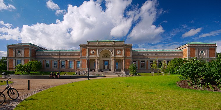
Photo: Jiří Komárek, CC BY-SA 4.0.
The National Gallery of Denmark is the Danish national gallery, located in the centre of Copenhagen. The museum collects, registers, maintains, researches and handles Danish and foreign art dating from the 14th century to the present day. National art museum Copenhagen is situated 210 metres west of Geocenter København.
castle Rosenborg

Photo: Kallerna, CC BY-SA 4.0.
Rosenborg Castle is a renaissance castle in Copenhagen, Denmark. The castle was originally built as a country summerhouse in 1606 and is an example of Christian IV's many architectural projects. castle Rosenborg is situated 400 metres southwest of Geocenter København.
Hirschsprung Collection
Museum
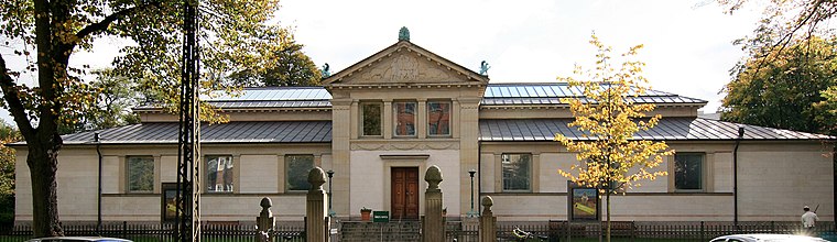
Photo: Mahlum, Public domain.
The Hirschsprung Collection is an art museum located on Stockholmsgade in Copenhagen, Denmark. It is located in a parkland setting in Østre Anlæg, near the Danish National Gallery, and houses a large collection of Danish art from the 19th and early 20th century. Hirschsprung Collection is situated 310 metres northwest of Geocenter København.
Places in the Area
Nearby places include Nyboder and Copenhagen.
Nyboder
Quarter

Photo: Wikimedia, CC BY-SA 3.0.
Nyboder is a historic row house district of former Naval barracks in Copenhagen, Denmark. It was planned and first built by Christian IV to accommodate a need for housing for the personnel of the rapidly growing Royal Danish Navy and their families during that time.
Copenhagen

Photo: Jjtkk, CC BY-SA 3.0.
Copenhagen is the capital city of Denmark and forms the moderate conurbation that one million Danes call home. It is big enough to form a small Danish metropolis, with shopping, culture and nightlife par excellence, yet small enough still to feel intimate and be safe.
Frederiksstaden
Quarter

Photo: Manscher, CC BY-SA 3.0.
Frederiksstaden is a district in Copenhagen, Denmark. Constructed during the reign of Frederick V in the second half of the 18th century, it is considered to be one of the most important rococo complexes in Europe and was included in the 2006 Danish Culture Canon.
Geocenter København
- Type: Educational institution
- Categories: office and education
- Location: Indre By, Copenhagen municipality, Capital Region, Denmark, Nordic countries, Europe
- View on OpenStreetMap
Latitude
55.68838° or 55° 41′ 18″ northLongitude
12.58158° or 12° 34′ 54″ eastOperator
Københavns UniversitetOpen location code
9F7JMHQJ+9JOpenStreetMap ID
node 25902751OpenStreetMap feature
office=educational_institution
This page is based on OpenStreetMap, Wikidata, and Wikimedia Commons.
We’d love your help improving our open data sources. Thank you for contributing.
Satellite Map
Discover Geocenter København from above in high-definition satellite imagery.
Notable Places Nearby
Highlights include Gefion Gymnasium and Jónshús.
Nearby Places
Explore places such as Institut for Geovidenskab og Naturforvaltning and GEUS.
Denmark: Must-Visit Destinations
Delve into Copenhagen, Aarhus, Odense, and Aalborg.
Curious Places to Discover
Uncover intriguing places from every corner of the globe.
About Mapcarta. Data © OpenStreetMap contributors and available under the Open Database License". Text is available under the CC BY-SA 4.0 license, except for photos, directions, and the map. Photo: Wikimedia, CC BY-SA 3.0.