Oberbalm/Kirchweg
Oberbalm/Kirchweg is in Oberbalm, Bern-Mittelland, Canton of Bern and has an elevation of 819 metres. Oberbalm/Kirchweg is situated nearby to the garden Chrut & Uchrut Kräutergarten, as well as near the motorhome stopover Womo Stellplatz Balmberg.| Tap on a place to explore it |
Places of Interest Nearby
Highlights include Niederscherli railway station and Mittelhäusern railway station.
Niederscherli railway station
Railway station
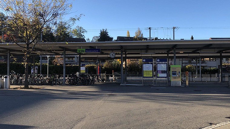 Niederscherli railway station is a railway station in the municipality of Köniz, in the Swiss canton of Bern. It is an intermediate stop on the standard gauge Bern–Schwarzenburg line of BLS AG. Niederscherli railway station is situated 2 km northwest of Oberbalm/Kirchweg.
Mittelhäusern railway station
Railway station
 Mittelhäusern railway station is a railway station in the municipality of Köniz, in the Swiss canton of Bern. It is an intermediate stop on the standard gauge Bern–Schwarzenburg line of BLS AG. Mittelhäusern railway station is situated 2½ km west of Oberbalm/Kirchweg.
Riedburg castle ruin
Castle

Photo: Ginkgo2g, CC BY-SA 4.0.
Riedburg castle ruin is situated 3 km west of Oberbalm/Kirchweg.
Places in the Area
Nearby places include Oberbalm and Oberscherli.
Oberbalm
Village
 Oberbalm, is a municipality in the Bern-Mittelland administrative district in the canton of Bern in Switzerland.


Oberbalm/Kirchweg
- Type: Sign
- Categories: information and tourism
- Location: Oberbalm, Bern-Mittelland, Canton of Bern, Switzerland, Central Europe, Europe
- View on OpenStreetMap
Latitude
46.87025° or 46° 52′ 13″ northLongitude
7.40253° or 7° 24′ 9″ eastElevation
819 metres (2,687 feet)Open location code
8FR9VCC3+42OpenStreetMap ID
node 2664054148OpenStreetMap feature
tourism=information
This page is based on OpenStreetMap, Wikidata, and Wikimedia Commons.
We’d love your help improving our open data sources. Thank you for contributing.
Satellite Map
Discover Oberbalm/Kirchweg from above in high-definition satellite imagery.
Notable Places Nearby
Highlights include Chrut & Uchrut Kräutergarten and Womo Stellplatz Balmberg.
Nearby Places
Explore places such as Feuerwehr Oberbalm Magazin and Oberbalm.
Switzerland: Must-Visit Destinations
Delve into Zurich, Berne, Geneva, and Basel.
Curious Places to Discover
Uncover intriguing places from every corner of the globe.
About Mapcarta. Data © OpenStreetMap contributors and available under the Open Database License". Text is available under the CC BY-SA 4.0 license, except for photos, directions, and the map. Photo: Simonizer, CC BY-SA 2.0 de.