Freiwillige Feuerwehr Kötzing
Freiwillige Feuerwehr Kötzing is a fire station in Seeboden am Millstätter See, Spittal an der Drau District, Carinthia. Freiwillige Feuerwehr Kötzing is situated nearby to the church Evangelische Pfarrkirche Unterhaus-Millstätter See, as well as near the pitch Ritterspiele Burg Sommeregg.| Tap on a place to explore it |
Places of Interest Nearby
Highlights include Burg Sommeregg and Evangelische Pfarrkirche Unterhaus-Millstätter See.
Burg Sommeregg
Castle
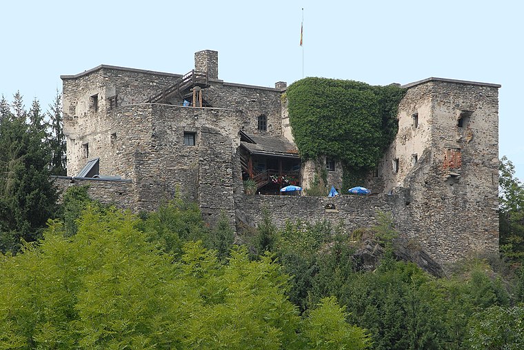
Photo: Johann Jaritz, CC BY-SA 3.0 at.
Sommeregg is a medieval castle near Seeboden in the Austrian state of Carinthia, Austria. It is situated in the foothills of the Nock Mountains at an altitude of 749 m. Burg Sommeregg is situated 1 km east of Freiwillige Feuerwehr Kötzing.
Evangelische Pfarrkirche Unterhaus-Millstätter See
Church
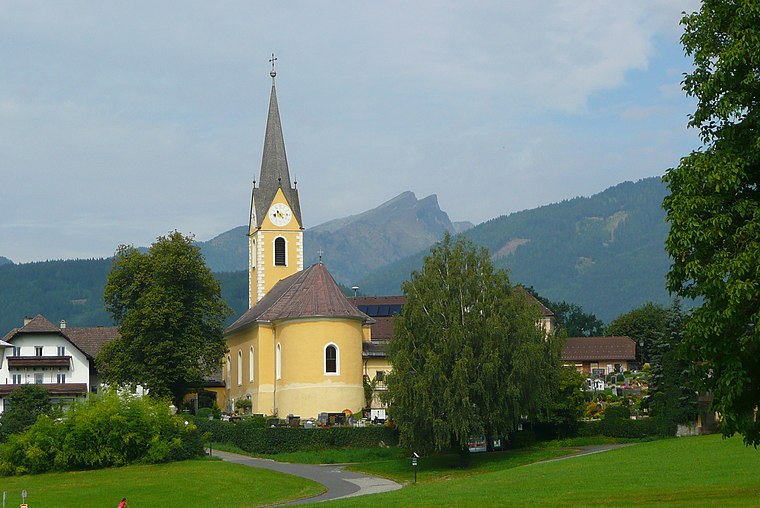
Photo: Peter Tritthart, CC BY 3.0.
Evangelische Pfarrkirche Unterhaus-Millstätter See is a church, which is situated 540 metres east of Freiwillige Feuerwehr Kötzing.
Pfarrkirche Mariae Himmelfahrt
Church

Photo: Joadl, CC BY-SA 3.0 at.
Pfarrkirche Mariae Himmelfahrt is a church, which is situated 1¼ km west of Freiwillige Feuerwehr Kötzing.
Places in the Area
Nearby places include Spittal an der Drau and Millstatt am See.
Spittal an der Drau

Photo: JJ55, Public domain.
Spittal an der Drau is a town in the western part of the Austrian federal state of Carinthia. It is the administrative centre of Spittal an der Drau District, Austria's second largest district by area.
Millstatt am See
Town

Photo: JOADL, CC BY-SA 3.0.
Millstatt am See is a market town of the Spittal an der Drau District in Carinthia, Austria. The traditional health resort and spa town on Lake Millstatt is known for former Benedictine Millstatt Abbey, founded about 1070. Millstatt am See is situated 6 km southeast of Freiwillige Feuerwehr Kötzing.
Baldramsdorf
Village

Photo: Wikimedia, CC BY-SA 3.0.
Baldramsdorf is a municipality in the district of Spittal an der Drau in the Austrian state of Carinthia. Baldramsdorf is situated 6 km southwest of Freiwillige Feuerwehr Kötzing.
Freiwillige Feuerwehr Kötzing
Latitude
46.83309° or 46° 49′ 59″ northLongitude
13.50985° or 13° 30′ 36″ eastOpen location code
8FRMRGM5+6WOpenStreetMap ID
node 2667600184OpenStreetMap feature
amenity=fire_station
This page is based on OpenStreetMap, Wikidata, and Wikimedia Commons.
We’d love your help improving our open data sources. Thank you for contributing.
Satellite Map
Discover Freiwillige Feuerwehr Kötzing from above in high-definition satellite imagery.
Notable Places Nearby
Highlights include Ritterspiele Burg Sommeregg and Foltermuseum Burg Sommeregg.
Nearby Places
Explore places such as Deutsch and Pirk.
Carinthia: Must-Visit Destinations
Delve into Klagenfurt, Villach, Wörthersee, and Spittal an der Drau.
Curious Fire Stations to Discover
Uncover intriguing fire stations from every corner of the globe.
About Mapcarta. Data © OpenStreetMap contributors and available under the Open Database License". Text is available under the CC BY-SA 4.0 license, except for photos, directions, and the map. Photo: Hfst, CC BY-SA 4.0.