Góra Cygańska
Góra Cygańska is a peak in Gdańsk, Pomorskie and has an elevation of 82 metres. Góra Cygańska is situated nearby to the neighborhood Cygańska Góra, as well as near the locality Pogańska Góra.| Tap on a place to explore it |
Places of Interest
Highlights include Gdańsk Główny Railway Station and Solidarity Museum (European Solidarity Centre).
Gdańsk Główny Railway Station
Railway station
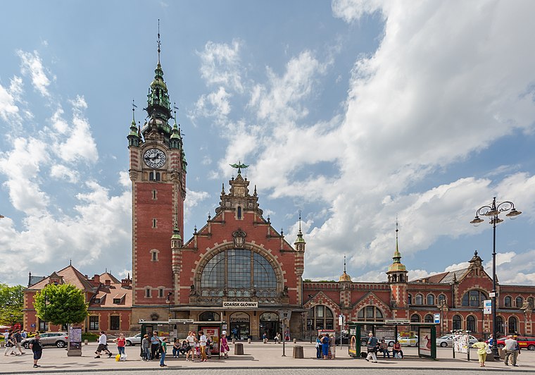
Photo: Wikimedia, CC BY-SA 3.0.
Gdańsk Główny is the chief railway station serving the city of Gdańsk, in the Pomeranian Voivodeship, Poland. The station opened in 1900 and is located on the Warsaw–Gdańsk railway, Gdańsk–Stargard railway, the parallel Gdańsk Śródmieście–Rumia railway, Gdańsk Główny–Gdańsk Zaspa Towarowa railway and Gdańsk Główny–Gdańsk Nowy Port railway.
Solidarity Museum (European Solidarity Centre)
Museum

Photo: Fallaner, CC BY-SA 4.0.
The European Solidarity Centre is a museum and library in Gdańsk, Poland, devoted to the history of Solidarity, the Polish trade union and civil resistance movement, and other opposition movements of Communist Eastern Europe. It opened on 31 August 2014.
St Mary’s Church
Church
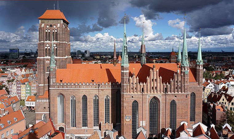 St. Mary's Church is a Roman Catholic church and co-cathedral located in central Gdańsk, Poland. Completed in 1502 in the Brick Gothic architectural style, it is one of the world's largest brick churches and among the city's most important landmarks, known to its inhabitants as the Crown of Gdańsk.
Places in the Area
Nearby places include Chełm and Piecki-Migowo.
Chełm
Suburb

Photo: Artur Andrzej, CC BY-SA 4.0.
Chełm is an administrative district of the city of Gdańsk, Poland. Although once the most populous district of the city, its size and population were significantly reduced from 2010 up until 2019 as new districts were separated from it.
Piecki-Migowo
Suburb

Photo: Tsca, CC BY 2.5 pl.
Piecki-Migowo, popularly called Morena, is a district of the city of Gdańsk, Poland. It is a growing suburban area and comprises two former villages: Piecki and Migowo.
Ujeścisko-Łostowice
Suburb

Photo: Artur Andrzej, CC0.
Ujeścisko-Łostowice is one of the administrative districts of the city of Gdańsk, Poland. Currently, it is one of the city's most rapidly developing and most populous suburban areas.
Góra Cygańska
- Type: Peak with an elevation of 82 metres
- Also known as: “Suchańska Góra”
- Category: landform
- Location: Gdańsk, Pomorskie, Poland, Central Europe, Europe
- View on OpenStreetMap
Latitude
54.3573° or 54° 21′ 26″ northLongitude
18.6142° or 18° 36′ 51″ eastElevation
82 metres (269 feet)Open location code
9F6W9J47+WMOpenStreetMap ID
node 2771862982OpenStreetMap feature
natural=peak
This page is based on OpenStreetMap, Wikidata, and Wikimedia Commons.
We’d love your help improving our open data sources. Thank you for contributing.
Satellite Map
Discover Góra Cygańska from above in high-definition satellite imagery.
Localities in the Area
Explore places such as Cygańska Góra and Pogańska Góra.
Notable Places Nearby
Highlights include Zdrofit and Staw Cyganka.
Pomorskie: Must-Visit Destinations
Delve into Gdynia, Sopot, Malbork, and Puck.
Curious Peaks to Discover
Uncover intriguing peaks from every corner of the globe.
About Mapcarta. Data © OpenStreetMap contributors and available under the Open Database License". Text is available under the CC BY-SA 4.0 license, except for photos, directions, and the map. Photo: Yarl, CC BY-SA 3.0.