Jurčići
Jurčići is a neighborhood in Town of Kastav, Primorje-Gorski Kotar County. Jurčići is situated nearby to the town Kastav, as well as near the neighborhood Ćikovići.| Tap on a place to explore it |
Places of Interest
Highlights include Stadion Kantrida and Opatija-Matulji.
Stadion Kantrida
Stadium
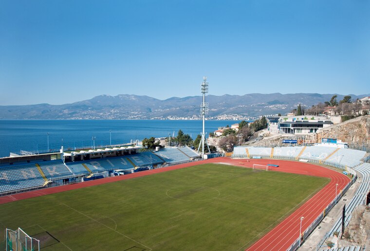
Photo: Roberta F., CC BY-SA 3.0.
Kantrida Stadium is a football stadium in the Croatian city of Rijeka. It is named after the Kantrida neighbourhood in which it is located, in the western part of the city. Stadion Kantrida is situated 4 km southeast of Jurčići.
Opatija-Matulji
Railway station

Photo: Roberta F., CC BY-SA 3.0.
Opatija-Matulji is a railway station, which is situated 2½ km west of Jurčići.
Centar Zamet
Sports venue

Photo: Roberta F., CC BY-SA 3.0.
Centar Zamet, also rendered in English as Zamet Sports Centre, is a mixed-use sports hall in the Zamet neighbourhood of Rijeka, Croatia, that hosts sporting, cultural, business and entertainment events. Centar Zamet is situated 3½ km southeast of Jurčići.
Places in the Area
Nearby places include Kastav and Srdoči.
Kastav
Town

Photo: Modzzak, CC BY-SA 3.0.
Kastav is a town in Primorje-Gorski Kotar County, western part of Croatia, built on a 365 m high hill overlooking the Kvarner Gulf on the northern coast of the Adriatic.

Matulji
Village

Photo: Roberta F., CC BY-SA 3.0.
Matulji is a municipality in Primorje-Gorski Kotar County, northwestern Croatia. It is located 10 kilometers west of the city of Rijeka, north of the town of Opatija, and it borders Slovenia.
Jurčići
- Type: Neighborhood
- Category: locality
- Location: Town of Kastav, Primorje-Gorski Kotar County, Croatia, Balkans, Europe
- View on OpenStreetMap
Latitude
45.36784° or 45° 22′ 4″ northLongitude
14.35342° or 14° 21′ 12″ eastOpen location code
8FQP9993+49OpenStreetMap ID
node 2835862821OpenStreetMap feature
place=neighbourhood
This page is based on OpenStreetMap, Wikidata, and Wikimedia Commons.
We’d love your help improving our open data sources. Thank you for contributing.
Satellite Map
Discover Jurčići from above in high-definition satellite imagery.
Places with the Same Name
Discover other places named “Jurčići”.
Localities in the Area
Explore places such as Ćikovići and Rešetari.
Notable Places Nearby
Highlights include Igralište Petar Jurčić and Kapela sv. Mihovila.
Croatia: Must-Visit Destinations
Delve into Zagreb, Dubrovnik, Split, and Rijeka.
Curious Neighborhoods to Discover
Uncover intriguing neighborhoods from every corner of the globe.
About Mapcarta. Data © OpenStreetMap contributors and available under the Open Database License". Text is available under the CC BY-SA 4.0 license, except for photos, directions, and the map. Photo: Wikimedia, CC BY-SA 3.0.