Längfluh Sessel
Längfluh Sessel is an aerial lift in Valais, Switzerland. Längfluh Sessel is situated nearby to the peak Guglen, as well as near Eggfluh.| Tap on a place to explore it |
Places of Interest Nearby
Highlights include Dom and Lenzspitze.
Dom
Peak

Photo: Zacharie Grossen, CC BY-SA 3.0.
The Dom is a mountain of the Pennine Alps, located between Randa and Saas-Fee in the canton of Valais in Switzerland. With a height of 4,546 m, it is the seventh highest summit in the Alps, overall. Dom is situated 3 km west of Längfluh Sessel.
Lenzspitze
Peak
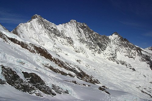
Photo: Wikimedia, CC BY-SA 3.0.
The Lenzspitze is a 4,293-metre mountain in the Pennine Alps in Switzerland. It is the southernmost peak on the Nadelgrat, a high-level ridge running roughly north–south, north of Dom in the Mischabel range, above the resort of Saas Fee to the east, and the Mattertal to the west. Lenzspitze is situated 2½ km northwest of Längfluh Sessel.
Täschhorn
Peak

Photo: Björn S..., CC BY-SA 2.0.
The Täschhorn is a mountain in the Pennine range of the Alps in Switzerland. There are no easy mountaineering routes to its summit, and it is regarded as being among the top ten 4,000-metre mountains in the Alps for difficulty, and "one of the highest, finest and least accessible 4000m mountains". Täschhorn is situated 3 km west of Längfluh Sessel.
Places in the Area
Nearby places include Saas-Fee and Plattjen.
Saas-Fee

Photo: Gürkan Sengün, CC BY-SA 3.0.
Saas-Fee is the biggest town in the Saas valley in the Swiss canton of Valais. The valley is a destination for winter sport, with the slopes in Saas fee being one of the few places in the region where skiing in summer is possible.
Plattjen
Locality

Photo: Wandervogel, CC BY-SA 3.0.
Plattjen is a locality, which is situated 4 km east of Längfluh Sessel.
Saas-Almagell
Village
Saas-Almagell is a municipality in the district of Visp in the canton of Valais in Switzerland. Saas-Almagell is situated 5 km east of Längfluh Sessel.
Längfluh Sessel
- Type: Aerial lift
- Categories: station and transportation
- Location: Valais, Switzerland, Central Europe, Europe
- View on OpenStreetMap
Latitude
46.09061° or 46° 5′ 26″ northLongitude
7.89441° or 7° 53′ 40″ eastOpen location code
8FR93VRV+6QOpenStreetMap ID
node 288322516OpenStreetMap feature
aerialway=stationOpenStreetMap feature
public_transport=station
This page is based on OpenStreetMap, Wikidata, and Wikimedia Commons.
We’d love your help improving our open data sources. Thank you for contributing.
Satellite Map
Discover Längfluh Sessel from above in high-definition satellite imagery.
Places with the Same Name
Discover other places named “Längfluh Sessel”.
Notable Places Nearby
Highlights include Guglen and Eggfluh.
Nearby Places
Explore places such as Talstation Längfluh and Längfluh.
Valais: Must-Visit Destinations
Delve into Sion, Zermatt, Martigny, and Brig.
Curious Aerial Lifts to Discover
Uncover intriguing aerial lifts from every corner of the globe.
About Mapcarta. Data © OpenStreetMap contributors and available under the Open Database License". Text is available under the CC BY-SA 4.0 license, except for photos, directions, and the map. Photo: Debugman, CC BY 3.0.