Hawk’s Nest Overlook
Hawk’s Nest Overlook is a scenic viewpoint in Fayette, West Virginia. Hawk’s Nest Overlook is situated nearby to Gauley Junction Dam, as well as near Hawks Nest State Park.| Tap on a place to explore it |
Places of Interest Nearby
Highlights include Hawks Nest State Park and Mystery Hole.
Hawks Nest State Park
Park
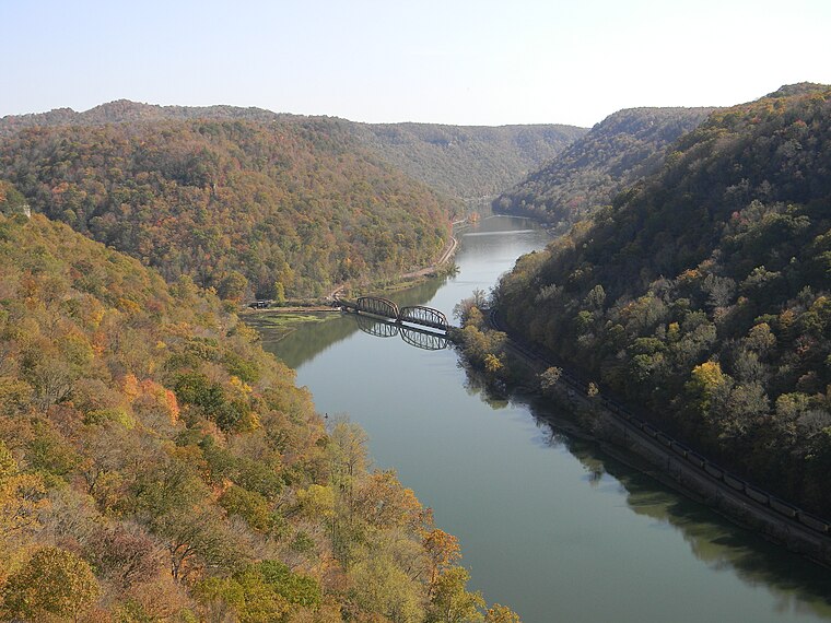
Photo: NKS22, Public domain.
Hawks Nest State Park is located on 370 acres in Fayette County near Ansted, West Virginia. The park's clifftop overlook along U.S. Route 60 provides a scenic vista of the New River, some 750 feet below.
Mystery Hole
Mystery Hole is located in Ansted, West Virginia, near Hawks Nest State Park and Cathedral Falls in West Virginia. Mystery Hole was founded by Donald Wilson in 1973. Mystery Hole is situated 3,800 feet west of Hawk’s Nest Overlook.Places in the Area
Nearby places include Hawks Nest and Cotton Hill.
Hawks Nest
Hamlet
Hawk's Nest, the site of Hawks Nest State Park, is a peak on Gauley Mountain in Ansted, West Virginia, United States. The cliffs at this point rise 585 ft above the New River.
Cotton Hill
Hamlet
Cotton Hill is an unincorporated community in Fayette County, West Virginia, United States.
Chimney Corner
Hamlet
Chimney Corner is an unincorporated community in Fayette County, West Virginia, United States. Chimney Corner is located at the junction of U.S. Route 60 and West Virginia Route 16, 3.5 miles southeast of Gauley Bridge. Chimney Corner is situated 1½ miles northwest of Hawk’s Nest Overlook.
Hawk’s Nest Overlook
- Type: Scenic viewpoint
- Category: tourism
- Location: Fayette, West Virginia, South, United States, North America
- View on OpenStreetMap
Latitude
38.12206° or 38° 7′ 19″ northLongitude
-81.12796° or 81° 7′ 41″ westOpen location code
86CW4VCC+RROpenStreetMap ID
node 2924142769OpenStreetMap feature
tourism=viewpoint
This page is based on OpenStreetMap, Wikidata, and Wikimedia Commons.
We’d love your help improving our open data sources. Thank you for contributing.
Satellite Map
Discover Hawk’s Nest Overlook from above in high-definition satellite imagery.
Notable Places Nearby
Highlights include Gauley Junction Dam and Lover’s Leap Lookout.
Nearby Places
Explore places such as Hawk’s Nest Lodge and Cotton Hill Parking.
West Virginia: Must-Visit Destinations
Delve into Charleston, Huntington, Parkersburg, and Morgantown.
Curious Scenic Viewpoints to Discover
Uncover intriguing scenic viewpoints from every corner of the globe.
About Mapcarta. Data © OpenStreetMap contributors and available under the Open Database License". Text is available under the CC BY-SA 4.0 license, except for photos, directions, and the map. Photo: JaGa, CC BY-SA 4.0.