Stadtteilbüro EggenLend
Stadtteilbüro EggenLend is a community center in Lend, Graz, Styria which is located on Alte Poststraße. Stadtteilbüro EggenLend is situated nearby to the community center Familienzentrum WOHIN, as well as near Jugendzentrum EggenLend.| Tap on a place to explore it |
Places of Interest Nearby
Highlights include Vinzenzkirche, Graz and Graz Hauptbahnhof.
Vinzenzkirche, Graz
Church

Photo: Andi oisn, CC BY-SA 3.0.
Vinzenzkirche, Graz is a church, which is situated 250 metres northwest of Stadtteilbüro EggenLend.
Graz Hauptbahnhof
Railway station

Photo: Wikimedia, CC BY-SA 1.0 fi.
Graz Hauptbahnhof, abbreviated Graz Hbf, is the main railway station in Graz, the capital of the Austrian federal state Styria. The station is located some 2 kilometres west of the city centre, to which it is connected by tram. Graz Hauptbahnhof is situated 710 metres east of Stadtteilbüro EggenLend.
Helmut-List-Halle
Arts center

Photo: Go staw, CC BY-SA 4.0.
The Helmut-List-Halle is a multi-purpose event and concert hall in Graz, Austria. Housed in a former 1950s industrial building originally erected for AVL List, it was adaptively remodelled in 2003 by architect Markus Pernthaler to provide adequate acoustics and accommodate up to 2,400 spectators. Helmut-List-Halle is situated 770 metres northeast of Stadtteilbüro EggenLend.
Places in the Area
Nearby places include Smart City Graz and Eggenberg.

Eggenberg
Suburb
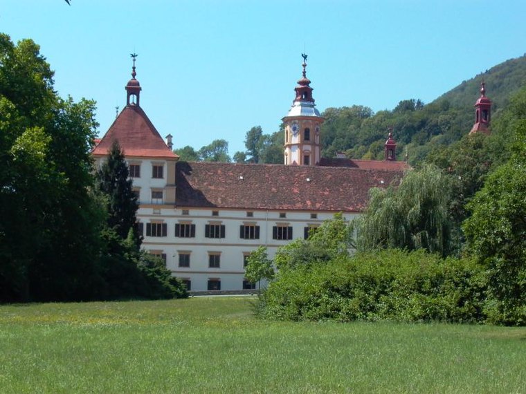
Photo: Robodoc, CC BY-SA 3.0.
Eggenberg is the 14th city district of Graz in the Austrian province of Styria. It borders to the districts of Lend and Gries in the east and to the Plabutsch mountain in the west.
Graz Reininghaus
Neighborhood

Photo: Wikimedia, CC BY-SA 3.0 de.
The grounds of the former Reininghaus brewery, covering 50 hectares, represent the largest undeveloped area near the center of Graz, Austria’s second largest city.
Stadtteilbüro EggenLend
- Type: Community center
- Address: Alte Poststraße 118, Graz, 8020
- Location: Lend, Graz, Styria, Austria, Central Europe, Europe
- View on OpenStreetMap
Latitude
47.07337° or 47° 4′ 24″ northLongitude
15.40792° or 15° 24′ 29″ eastOperator
WIKI Kinderbetreuungs GmbHOpen location code
8FVQ3CF5+85OpenStreetMap ID
node 2956899595OpenStreetMap feature
amenity=community_centre
This page is based on OpenStreetMap, Wikidata, and Wikimedia Commons.
We’d love your help improving our open data sources. Thank you for contributing.
Satellite Map
Discover Stadtteilbüro EggenLend from above in high-definition satellite imagery.
Notable Places Nearby
Highlights include Familienzentrum WOHIN and Jugendzentrum EggenLend.
Nearby Places
Explore places such as Rincon Andino and Dr. Leopold jun. Girtler.
Styria: Must-Visit Destinations
Delve into Leoben, Bruck an der Mur, Kapfenberg, and Schladming.
Curious Community Centers to Discover
Uncover intriguing community centers from every corner of the globe.
About Mapcarta. Data © OpenStreetMap contributors and available under the Open Database License". Text is available under the CC BY-SA 4.0 license, except for photos, directions, and the map. Photo: Traveler100, CC BY-SA 3.0.