Kolonia Lewartowskiego
Kolonia Lewartowskiego is a neighborhood in Gdańsk, Pomorskie. Kolonia Lewartowskiego is situated nearby to the locality Blaszanka, as well as near the neighborhood Rudno.| Tap on a place to explore it |
Places of Interest
Highlights include Żuławska Gate in Gdańsk and St Mary’s Church.

St Mary’s Church
Church
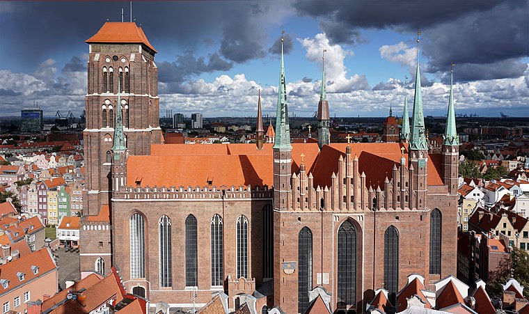 St. Mary's Church is a Roman Catholic church and co-cathedral located in central Gdańsk, Poland. Completed in 1502 in the Brick Gothic architectural style, it is one of the world's largest brick churches and among the city's most important landmarks, known to its inhabitants as the Crown of Gdańsk.
Gdańsk Crane

Photo: J budissin, CC BY-SA 3.0.
The Gdańsk Crane or the Crane Gate is a 15th-century crane located in central Gdańsk, Poland, on the Motława river. One of the city's most well-known structures and tourist attractions, it was the largest port crane in medieval Europe and is presently found on the regional heritage list.
Places in the Area
Nearby places include Rudno and Olszynka.
Rudno
Neighborhood
Rudno, commonly known as Knipawa, is a quarter of Śródmieście, a district of Gdańsk.
Olszynka
Suburb

Photo: Yusek, CC BY-SA 4.0.
Olszynka is one of the districts of the city of Gdańsk. It is located in the city's southeast.
Dolne Miasto
Quarter

Photo: GringoPL, CC BY-SA 3.0.
Dolne Miasto is a quarter of Śródmieście, a district of the city of Gdańsk.
Kolonia Lewartowskiego
- Type: Neighborhood
- Category: locality
- Location: Gdańsk, Pomorskie, Poland, Central Europe, Europe
- View on OpenStreetMap
Latitude
54.34398° or 54° 20′ 38″ northLongitude
18.67724° or 18° 40′ 38″ eastOpen location code
9F6W8MVG+HVOpenStreetMap ID
node 3009663979OpenStreetMap feature
place=neighbourhood
This page is based on OpenStreetMap, Wikidata, and Wikimedia Commons.
We’d love your help improving our open data sources. Thank you for contributing.
Satellite Map
Discover Kolonia Lewartowskiego from above in high-definition satellite imagery.
Localities in the Area
Explore places such as Blaszanka and Miałki Szlak.
Notable Places Nearby
Highlights include Punkt partnerski Orlen Paczka and Most Kapuściany.
Pomorskie: Must-Visit Destinations
Delve into Gdynia, Sopot, Malbork, and Puck.
Curious Neighborhoods to Discover
Uncover intriguing neighborhoods from every corner of the globe.
About Mapcarta. Data © OpenStreetMap contributors and available under the Open Database License". Text is available under the CC BY-SA 4.0 license, except for photos, directions, and the map. Photo: Yarl, CC BY-SA 3.0.