Servicio Regional de Andalucía Occidental del Instituto Geográfico Nacional
Servicio Regional de Andalucía Occidental del Instituto Geográfico Nacional is a government office in Granada, Granada, Andalusia which is located on Avenida Divina Pastora. Servicio Regional de Andalucía Occidental del Instituto Geográfico Nacional is situated nearby to the hotel Maciá Condor, as well as near the church Parroquia de la Inmaculada.| Tap on a place to explore it |
- Opening hours: Monday—Friday 9:00 AM—2:00 PM
- Type: Government office
- Also known as: “Instituto Geográfico Nacional de Granada”
- Address: 15, Avenida Divina Pastora 7,9, Granada, 18012
Places of Interest Nearby
Highlights include Alhambra and Gardens of the Triumph.
Alhambra
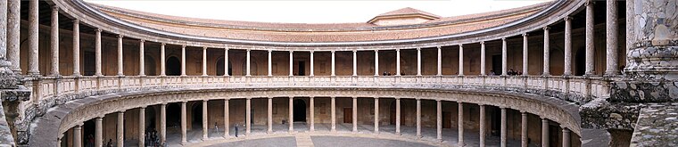
Photo: Bernd Untiedt, CC BY-SA 3.0.
The Alhambra is a palace and fortress complex located in Granada, Spain. It is one of the most famous monuments of Islamic architecture and one of the best-preserved palaces of the historic Islamic world. Alhambra is situated 1½ km southeast of Servicio Regional de Andalucía Occidental del Instituto Geográfico Nacional.

Gate of Elvira

Photo: Paul Hermans, CC BY-SA 3.0.
The Gate of Elvira is an arch located in Granada, Spain. It was declared Bien de Interés Cultural in 1896. It is located at the beginning of Calle Elvira, on the edge of the Albaicín neighbourhood. Gate of Elvira is situated 400 metres southeast of Servicio Regional de Andalucía Occidental del Instituto Geográfico Nacional.
Places in the Area
Nearby places include Pajaritos and Albaicín.

Albaicín
Quarter

Photo: Miguel303xm, CC BY-SA 2.5.
The Albaicín, also spelled Albayzín, is a neighbourhood of Granada, Spain. It is centered around a hill on the north side of the Darro River which passes through the city.
Sacromonte
Neighborhood
 Sacromonte, sometimes also called Sacramonte, is a traditional neighbourhood in the eastern area of the city of Granada in Andalusia, Spain. It is one of the six neighbourhoods that make up the urban district of Albayzín and borders the neighbourhoods of Albayzín, San Pedro, Realejo-San Matías, El Fargue and Haza Grande.
Servicio Regional de Andalucía Occidental del Instituto Geográfico Nacional
- Categories: office and government building
- Location: Granada, Granada, Andalusia, Spain, Iberia, Europe
- View on OpenStreetMap
Latitude
37.18446° or 37° 11′ 4″ northLongitude
-3.60301° or 3° 36′ 11″ westOpen location code
8C9R59MW+QQOpenStreetMap ID
node 3122448054OpenStreetMap feature
office=government
This page is based on OpenStreetMap, Wikidata, and Wikimedia Commons.
We’d love your help improving our open data sources. Thank you for contributing.
Satellite Map
Discover Servicio Regional de Andalucía Occidental del Instituto Geográfico Nacional from above in high-definition satellite imagery.
Notable Places Nearby
Highlights include Maciá Condor and Cripta de Fray Leopoldo de Alpandeire.
Nearby Places
Explore places such as Monte de Piedad and Caixabank.
Granada: Must-Visit Destinations
Delve into Almuñécar, Alhama de Granada, Portugos, and La Alpujarra.
Curious Government Offices to Discover
Uncover intriguing government offices from every corner of the globe.
About Mapcarta. Data © OpenStreetMap contributors and available under the Open Database License". Text is available under the CC BY-SA 4.0 license, except for photos, directions, and the map. Photo: Ogre, Public domain.