Orczy Kalandpark
Orczy Kalandpark is a sports venue in Budapest, Central Hungary which is located on Orczy út. Orczy Kalandpark is situated nearby to the sports venue Tóparti Épület, as well as near the pitch bemelegítő tornacsarnok.| Tap on a place to explore it |
- Opening hours: Saturday—Sunday 10:00 AM—6:00 PM
- Email: info@orczykalandpark.eu
- Type: Sports venue
- Address: Orczy út 1, Budapest, 1089
Places of Interest Nearby
Highlights include Hungarian Natural History Museum and Ferencváros Stadion.
Hungarian Natural History Museum
Museum
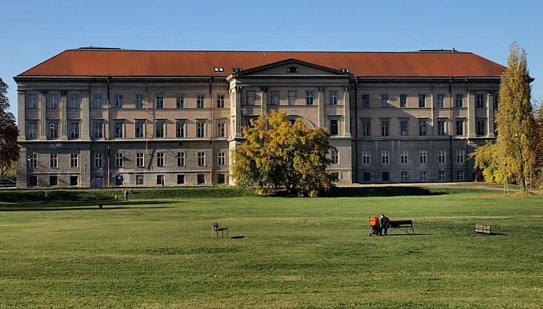
Photo: Misibacsi, CC BY-SA 3.0.
The Hungarian Natural History Museum in Budapest, dating back to 1802, houses the largest natural history collections of Hungary and the region. Hungarian Natural History Museum is situated 290 metres west of Orczy Kalandpark.
Ferencváros Stadion
Stadium

Photo: Cezarika1, CC BY-SA 4.0.
The Ferencváros Stadion, also known as the Groupama Aréna for sponsorship purposes, is a multi-purpose stadium in Ferencváros, Budapest, Hungary and the home of Ferencvárosi TC. Ferencváros Stadion is situated 1 km southeast of Orczy Kalandpark.
Heim Pál National Pediatric Institute
Hospital

Photo: RepliCarter, CC BY-SA 3.0.
Heim Pál National Pediatric Institute is a children's hospital located in several locations in Budapest, Hungary. Heim Pál National Pediatric Institute is situated 460 metres southeast of Orczy Kalandpark.
Places in the Area
Nearby places include Tisztviselőtelep and Józsefváros.

Józsefváros
 Józsefváros is the traditional name of the VIII. district, literally meaning "Josephtown" and referring to Emperor Joseph II of Austria and Hungary. This area is popular, with scores of students and several cafés and pizzerias.

Orczy Kalandpark
- Categories: climbing site, recreation area, and sports location
- Location: Budapest, Central Hungary, Hungary, Central Europe, Europe
- View on OpenStreetMap
Latitude
47.48245° or 47° 28′ 57″ northLongitude
19.08946° or 19° 5′ 22″ eastOpen location code
8FVXF3JQ+XQOpenStreetMap ID
node 3122781619OpenStreetMap feature
leisure=sports_centreOpenStreetMap feature
sport=climbing_adventure
This page is based on OpenStreetMap, Wikidata, and Wikimedia Commons.
We’d love your help improving our open data sources. Thank you for contributing.
Satellite Map
Discover Orczy Kalandpark from above in high-definition satellite imagery.
Notable Places Nearby
Highlights include Tóparti Épület and bemelegítő tornacsarnok.
Nearby Places
Explore places such as Kossuth and Buttler Terasz.
Budapest: Must-Visit Destinations
Delve into Belváros, Víziváros, Óbuda, and East Pest.
Curious Sports Venues to Discover
Uncover intriguing sports venues from every corner of the globe.
About Mapcarta. Data © OpenStreetMap contributors and available under the Open Database License". Text is available under the CC BY-SA 4.0 license, except for photos, directions, and the map. Photo: Chmehl, CC BY 3.0.