Julius-Raab-Platz (Stubenring)
Julius-Raab-Platz (Stubenring) is a tram stop in Innere Stadt, Vienna. Julius-Raab-Platz (Stubenring) is situated nearby to the work of art Ministerienbrunnen, as well as near the health club FAME Boxing.| Tap on a place to explore it |
Places of Interest Nearby
Highlights include Urania and University of Applied Arts Vienna.
Urania

Photo: Gryffindor, CC BY 2.5.
Urania is a public educational institute and observatory in Vienna, Austria. Urania Observatory was built in 1909 according to the plans of Art Nouveau style architect Max Fabiani at the outlet of the Wien River and was opened in 1910 by Franz Joseph I of Austria as an educational facility with a public observatory. Urania is situated 160 metres northeast of Julius-Raab-Platz (Stubenring).
University of Applied Arts Vienna
University

Photo: Maclemo, CC BY-SA 3.0.
The University of Applied Arts Vienna is an arts university and institution of higher education in Vienna, the capital of Austria. It has had university status since 1970. University of Applied Arts Vienna is situated 240 metres south of Julius-Raab-Platz (Stubenring).
Museum of Applied Arts, Vienna
Museum
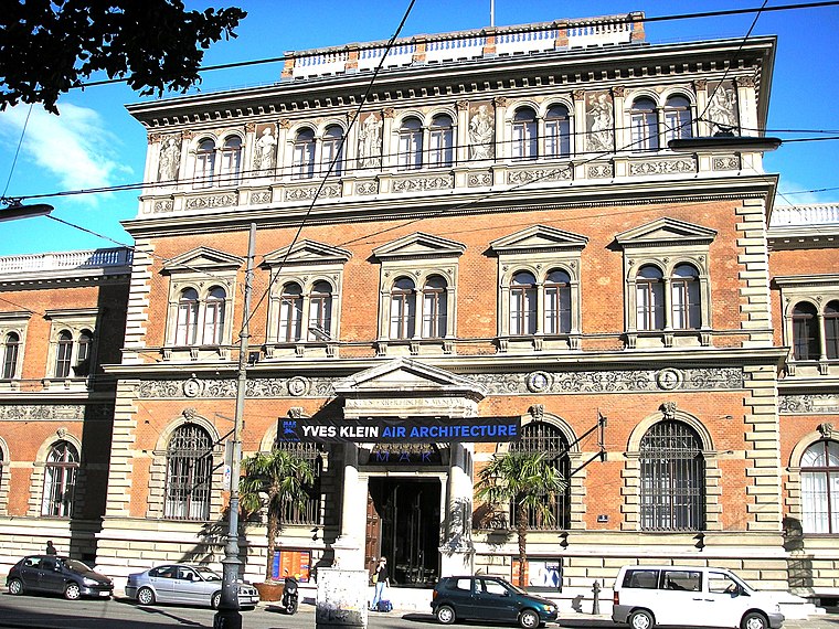
Photo: Gryffindor, CC BY 2.5.
The MAK – Museum of Applied Arts is an arts and crafts museum located at Stubenring 5 in Vienna's 1st district Innere Stadt. Besides its traditional orientation towards arts and crafts and design, the museum especially focuses on architecture and contemporary art. Museum of Applied Arts, Vienna is situated 330 metres south of Julius-Raab-Platz (Stubenring).
Places in the Area
Nearby places include Bermudadreieck and Inner East.

Inner East

Photo: Wikimedia, CC BY-SA 3.0.
Vienna's Inner East is an artificial island formed between the river and the Donaukanal. The island contains large expanses of parks and forests, including the famous Prater park with the permanent funfair including the Riesenrad Ferris wheel.

Julius-Raab-Platz (Stubenring)
- Type: Tram stop
- Also known as: “Julius-Raab-Platz”
- Categories: railway stop, transport stop, and transportation
- Location: Innere Stadt, Vienna, Austria, Central Europe, Europe
- View on OpenStreetMap
Latitude
48.21034° or 48° 12′ 37″ northLongitude
16.38254° or 16° 22′ 57″ eastOperator
Wiener LinienNetwork
Verkehrsverbund Ost-RegionOpen location code
8FWR696M+42OpenStreetMap ID
node 314051552OpenStreetMap feature
public_transport=stop_positionOpenStreetMap feature
railway=tram_stopWikidata ID
Q132177117
This page is based on OpenStreetMap, Wikidata, and Wikimedia Commons.
We’d love your help improving our open data sources. Thank you for contributing.
Satellite Map
Discover Julius-Raab-Platz (Stubenring) from above in high-definition satellite imagery.
In Other Languages
From French to German—“Julius-Raab-Platz (Stubenring)” goes by many names.
- French: “Julius-Raab-Platz (Stubenring)”
- German: “Julius-Raab-Platz (Stubenring)”
Notable Places Nearby
Highlights include Ministerienbrunnen and FAME Boxing.
Nearby Places
Explore places such as Julius-Raab-Platz and Ichi Go Ichi E.
Vienna: Must-Visit Destinations
Delve into Vienna International Airport, Inner East, Hietzing, and Landstraße.
Curious Tram Stops to Discover
Uncover intriguing tram stops from every corner of the globe.
About Mapcarta. Data © OpenStreetMap contributors and available under the Open Database License". Text is available under the CC BY-SA 4.0 license, except for photos, directions, and the map. Photo: Thoodor, CC BY-SA 3.0 at.