Eastern Harbour Tunnel BBI
Eastern Harbour Tunnel BBI is a bus stop in Kwun Tong District, Hong Kong. Eastern Harbour Tunnel BBI is situated nearby to the park Yau Tong Road Playground, as well as near the community center HARTS CSSC.| Tap on a place to explore it |
Places of Interest Nearby
Highlights include Yau Tong station and Tin Hau Temple (Cha Kwo Ling).
Yau Tong station
Railway station

Photo: Qwer132477, CC BY-SA 3.0.
Yau Tong is a station on the Hong Kong MTR Kwun Tong line and the Tseung Kwan O line. It is the only station of the Tseung Kwan O line located in Kowloon. Yau Tong station is situated 540 metres southeast of Eastern Harbour Tunnel BBI.
Tin Hau Temple (Cha Kwo Ling)
Place of worship
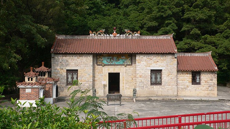
Photo: Father vice, CC BY-SA 3.0.
Tin Hau Temple (Cha Kwo Ling) is a place of worship, which is situated 420 metres southwest of Eastern Harbour Tunnel BBI.
Sceneway Plaza
Shopping center

Photo: WiNG, CC BY-SA 3.0.
Hong Kong Sceneway Plaza is a shopping centre in Lam Tin, Kowloon, Hong Kong. It also contains the East Kowloon Office of the Immigration Department. Opened in February 1992, the shopping centre is located adjacent to Lam Tin station of Hong Kong's Mass Transit Railway. Sceneway Plaza is situated 670 metres north of Eastern Harbour Tunnel BBI.
Places in the Area
Nearby places include Cha Kwo Ling and Yau Tong.
Cha Kwo Ling
Suburb

Photo: Mk2010, CC BY-SA 4.0.
Cha Kwo Ling is a hill in the eastern New Kowloon area of Hong Kong, and the area around it. It is adjacent to Victoria Harbour and located to the west of Yau Tong and southwest of Lam Tin.
Yau Tong
Suburb

Photo: Nhk9, CC BY-SA 4.0.
Yau Tong is an area of Hong Kong, located in the southeastern end of Kowloon, between Lei Yue Mun and Lam Tin, at the east shore of Victoria Harbour, west of Tseung Kwan O.
Kwun Tong
Suburb

Photo: Wing1990hk, CC BY 3.0.
Kwun Tong is an area in the Kwun Tong District of Hong Kong, situated at the eastern part of the Kowloon Peninsula, and its boundary stretches from Lion Rock in the north to Lei Yue Mun in the south, and from the winding paths of Kowloon Peak in the east to the north coast of the former Kai Tak Airport runway in the west.
Eastern Harbour Tunnel BBI
- Type: Bus stop
- Category: transportation
- Location: Kwun Tong District, Hong Kong, East Asia, Asia
- View on OpenStreetMap
Latitude
22.30114° or 22° 18′ 4″ northLongitude
114.23334° or 114° 14′ eastOperator
九巴 KMBOpen location code
7PJP862M+F8OpenStreetMap ID
node 3154222415OpenStreetMap feature
highway=bus_stopOpenStreetMap feature
public_transport=platform
This page is based on OpenStreetMap, Wikidata, and Wikimedia Commons.
We’d love your help improving our open data sources. Thank you for contributing.
Satellite Map
Discover Eastern Harbour Tunnel BBI from above in high-definition satellite imagery.
In Other Languages
“Eastern Harbour Tunnel BBI” goes by many names.
- Chinese: “東隧轉車站”
Notable Places Nearby
Highlights include Yau Tong Road Playground and HARTS CSSC.
Nearby Places
Explore places such as Eastern Harbour Tunnel BBI and Eastern Harbour Crossing Bus-Bus Interchange.
Hong Kong: Must-Visit Destinations
Delve into Kowloon, Hong Kong International Airport, Outlying Islands, and Central Hong Kong.
Curious Bus Stops to Discover
Uncover intriguing bus stops from every corner of the globe.
About Mapcarta. Data © OpenStreetMap contributors and available under the Open Database License". Text is available under the CC BY-SA 4.0 license, except for photos, directions, and the map. Photo: Base64, CC BY-SA 3.0.