Selma Schnog
Selma Schnog is a memorial in Cologne, Cologne Lowland, North Rhine-Westphalia. Selma Schnog is situated nearby to the community center Evangelisches Familien- und Gemeindezentrum, as well as near the square Am Düxer Bock.| Tap on a place to explore it |
Places of Interest Nearby
Highlights include Lanxess Arena and Cologne Cathedral.
Lanxess Arena
Stadium
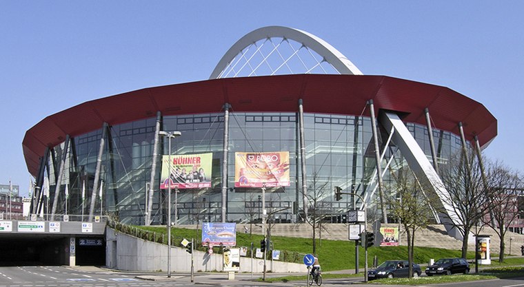
Photo: Hps-poll, CC BY-SA 3.0.
Lanxess Arena is an indoor arena, in Cologne, North Rhine-Westphalia, Germany. It is known as the 18,500-capacity home of the Kölner Haie and as one of Germany's major music venues. Lanxess Arena is situated 680 metres northeast of Selma Schnog.
Cologne Cathedral
Church

Photo: Der Wolf im Wald, CC BY-SA 3.0 de.
Cologne Cathedral is a cathedral in Cologne, North Rhine-Westphalia belonging to the Catholic Church. It is the seat of the Archbishop of Cologne and of the administration of the Archdiocese of Cologne. Cologne Cathedral is situated 1½ km northwest of Selma Schnog.
St. Johanneskirche (Köln-Deutz)
Church

Photo: Chris06, CC BY-SA 4.0.
St. Johanneskirche (Köln-Deutz) is a church, which is situated 150 metres northwest of Selma Schnog.
Places in the Area
Nearby places include Deutz and Agnesviertel.
Deutz
Suburb

Photo: Tohma, CC BY-SA 4.0.
The Cologne borough of Deutz is a part of central Cologne, Germany, and was once an independent town known as Deutz am Rhein.

Bayenthal
Suburb

Photo: ZH2010, CC BY-SA 3.0.
Bayenthal is a neighbourhood of Cologne, Germany and part of the district of Rodenkirchen. Bayenthal lies on the left bank of the river Rhine, between the district of Innenstadt to the North and Marienburg neighbourhood to the South. Bayenthal is situated 2½ km south of Selma Schnog.
Selma Schnog
- Type: Memorial
- Inscription: “Hier wohnte Selma Schnog Jg. 1897, deportiert Sobibor, für tot erklärt”
- Category: historic site
- Location: Cologne, Cologne District, Cologne Lowland, North Rhine-Westphalia, Germany, Central Europe, Europe
- View on OpenStreetMap
Latitude
50.93467° or 50° 56′ 5″ northLongitude
6.97528° or 6° 58′ 31″ eastNetwork
StolpersteineOpen location code
9F28WXMG+V4OpenStreetMap ID
node 3209374782OpenStreetMap feature
historic=memorial
This page is based on OpenStreetMap, Wikidata, and Wikimedia Commons.
We’d love your help improving our open data sources. Thank you for contributing.
Satellite Map
Discover Selma Schnog from above in high-definition satellite imagery.
Places with the Same Name
Discover other places named “Selma Schnog”.
Notable Places Nearby
Highlights include Evangelisches Familien- und Gemeindezentrum and Am Düxer Bock.
Nearby Places
Explore places such as Kath. KiTa St. Heribert and Jugendheim St. Heribert.
Cologne Lowland: Must-Visit Destinations
Delve into Bonn, Leverkusen, Siegburg, and Bad Honnef.
Curious Memorials to Discover
Uncover intriguing memorials from every corner of the globe.
About Mapcarta. Data © OpenStreetMap contributors and available under the Open Database License". Text is available under the CC BY-SA 4.0 license, except for photos, directions, and the map. Photo: Ahgee, CC BY-SA 3.0.