Weiherfeldbrücke
Weiherfeldbrücke is in Karlsruhe, Rhine-Neckar, Baden-Württemberg. Weiherfeldbrücke is situated nearby to the playground Spiel- und Sportanlage KGA Vorderbrüchle, as well as near the church Stephanienbad (Karlsruhe).| Tap on a place to explore it |
Places of Interest Nearby
Highlights include Stephanienbad (Karlsruhe) and Karlsruhe Albtalbahnhof.
Stephanienbad (Karlsruhe)
Church

Photo: Wikimedia, CC BY-SA 3.0.
Stephanienbad (Karlsruhe) is a church, which is situated 170 metres northwest of Weiherfeldbrücke.
Karlsruhe Albtalbahnhof
Railway station

Photo: MCMC, CC BY-SA 2.5.
Karlsruhe Albtalbahnhof is a railway station in Karlsruhe, Germany, next to Karlsruhe main station. The station is of particular importance for the city, as it is the station where tram-trains cross from the city's tram network to the regional and long-distance rail network. Karlsruhe Albtalbahnhof is situated 500 metres north of Weiherfeldbrücke.
Karlsruhe Zoo
Park
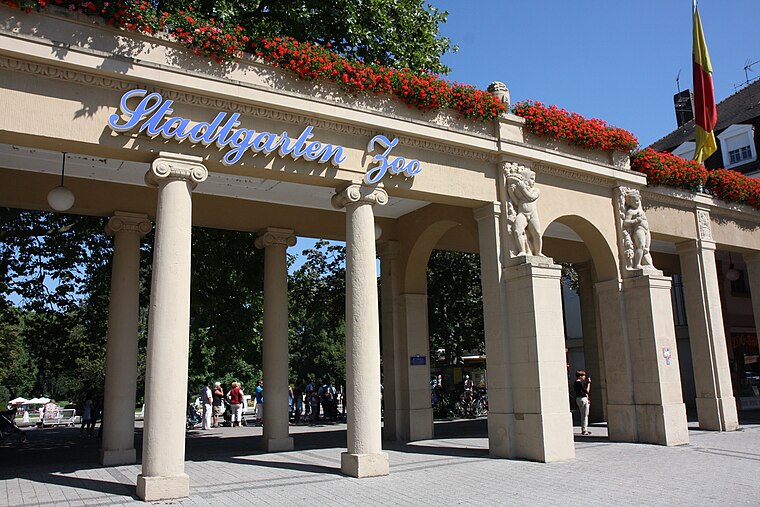
Photo: Root66, CC BY-SA 3.0.
The Karlsruhe Zoo is a city garden with a zoo in the southwest of Karlsruhe, Germany. It also encompasses the outer area; Tierpark Oberwald in the southeast of the city. Karlsruhe Zoo is situated 1 km northeast of Weiherfeldbrücke.
Places in the Area
Nearby places include Mühlburg and Wolfartsweier.
Mühlburg
Suburb

Photo: Baden-Paul, CC0.
Mühlburg is a district of Karlsruhe, Germany. The district is further divided into Alt-Mühlburg, Weingärtensiedlung, Rheinhafen and Mühlburger Feld. Mühlburg is situated 3½ km northwest of Weiherfeldbrücke.
Wolfartsweier
Suburb
Wolfartsweier is a village and a quarter of Karlsruhe, Baden-Württemberg, Germany. Its population is 3,068. It was first mentioned in 1261 AD under the name of "Wolvoldeswilere". Wolfartsweier is situated 5 km east of Weiherfeldbrücke.
Ettlingen

Photo: Martin-D, CC BY-SA 2.5.
Ettlingen, tucked between Karlsruhe and the Black Forest, is a small city with a history dating back to the Roman Empire.
Weiherfeldbrücke
- Type: Sign
- Categories: information and tourism
- Location: Karlsruhe, Karlsruhe Region, Rhine-Neckar, Baden-Württemberg, Germany, Central Europe, Europe
- View on OpenStreetMap
Latitude
48.98954° or 48° 59′ 22″ northLongitude
8.3935° or 8° 23′ 37″ eastElevation
114 metres (374 feet)Operator
SchwarzwaldvereinOpen location code
8FWCX9QV+R9OpenStreetMap ID
node 331823198OpenStreetMap feature
tourism=information
This page is based on OpenStreetMap, Wikidata, and Wikimedia Commons.
We’d love your help improving our open data sources. Thank you for contributing.
Satellite Map
Discover Weiherfeldbrücke from above in high-definition satellite imagery.
Notable Places Nearby
Highlights include Eisenbahnüberführung Weiherfeldbrücke and Spiel- und Sportanlage KGA Vorderbrüchle.
Nearby Places
Explore places such as Stellwerk 6 and Stellwerk 9.
Rhine-Neckar: Must-Visit Destinations
Delve into Heidelberg, Mannheim, Heilbronn, and Sinsheim.
Curious Places to Discover
Uncover intriguing places from every corner of the globe.
About Mapcarta. Data © OpenStreetMap contributors and available under the Open Database License". Text is available under the CC BY-SA 4.0 license, except for photos, directions, and the map. Photo: Ruhrfisch, CC BY-SA 3.0.