Recherswil Unterdorf
Recherswil Unterdorf is a bus stop in Recherswil, Wasseramt District, Canton of Solothurn. Recherswil Unterdorf is situated nearby to the sports venue Iguhalle, as well as near TAMTAM produktion.| Tap on a place to explore it |
Places of Interest Nearby
Highlights include Gerlafingen railway station and Bruder Klaus Gerlafingen.
Gerlafingen railway station
Railway station
 Gerlafingen railway station is a railway station in the municipality of Gerlafingen, in the Swiss canton of Solothurn. It is an intermediate stop on the standard gauge Solothurn–Langnau line of BLS AG. Gerlafingen railway station is situated 2½ km west of Recherswil Unterdorf.
Bruder Klaus Gerlafingen
Church

Photo: Charly Bernasconi, CC BY-SA 4.0.
Bruder Klaus Gerlafingen is a church, which is situated 2 km west of Recherswil Unterdorf.
Biberist Ost railway station
Railway station
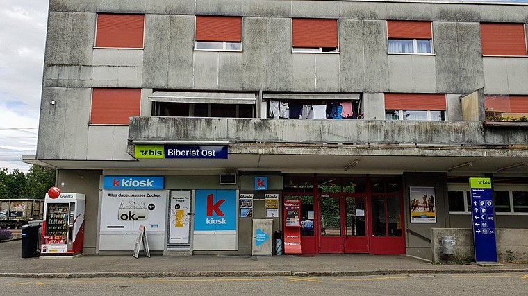 Biberist Ost railway station is a railway station in the municipality of Biberist, in the Swiss canton of Solothurn. It is an intermediate stop on the standard gauge Solothurn–Langnau line of BLS AG. Biberist Ost railway station is situated 2½ km northwest of Recherswil Unterdorf.
Places in the Area
Nearby places include Recherswil and Halten.
Recherswil
Village

Photo: Chriusha, CC BY-SA 3.0.
Recherswil is a municipality in the district of Wasseramt, in the canton of Solothurn in Switzerland.
Halten
Village

Photo: Gestumblindi, CC BY 3.0.
Halten is a municipality in the district of Wasseramt in the canton of Solothurn in Switzerland.
Kriegstetten
Village

Photo: Gestumblindi, CC BY 3.0.
Kriegstetten is a municipality in the district of Wasseramt in the canton of Solothurn in Switzerland.
Recherswil Unterdorf
- Type: Bus stop
- Also known as: “Recherswil, Schreinerei”
- Categories: transport stop and transportation
- Location: Recherswil, Wasseramt District, Canton of Solothurn, Switzerland, Central Europe, Europe
- View on OpenStreetMap
Latitude
47.16665° or 47° 9′ 60″ northLongitude
7.59572° or 7° 35′ 45″ eastOperator
BSGUNetwork
Libero-TarifverbundOpen location code
8FV95H8W+M7OpenStreetMap ID
node 3361884658OpenStreetMap feature
highway=bus_stopOpenStreetMap feature
public_transport=stop_position
This page is based on OpenStreetMap, Wikidata, and Wikimedia Commons.
We’d love your help improving our open data sources. Thank you for contributing.
Satellite Map
Discover Recherswil Unterdorf from above in high-definition satellite imagery.
Notable Places Nearby
Highlights include Iguhalle and TAMTAM produktion.
Nearby Places
Explore places such as Kastanienbaum and Kürzematthof.
Switzerland: Must-Visit Destinations
Delve into Zurich, Berne, Geneva, and Basel.
Curious Bus Stops to Discover
Uncover intriguing bus stops from every corner of the globe.
About Mapcarta. Data © OpenStreetMap contributors and available under the Open Database License". Text is available under the CC BY-SA 4.0 license, except for photos, directions, and the map. Photo: Simonizer, CC BY-SA 2.0 de.