The Falls Motel
The Falls Motel is a motel in Montour, Schuyler, New York which is located on North Genesee Street. The Falls Motel is situated nearby to the government office Village of Montour Falls, as well as near Montour Falls Memorial Library.| Tap on a place to explore it |
Places of Interest Nearby
Highlights include First Baptist Church of Watkins Glen.
First Baptist Church of Watkins Glen
Church
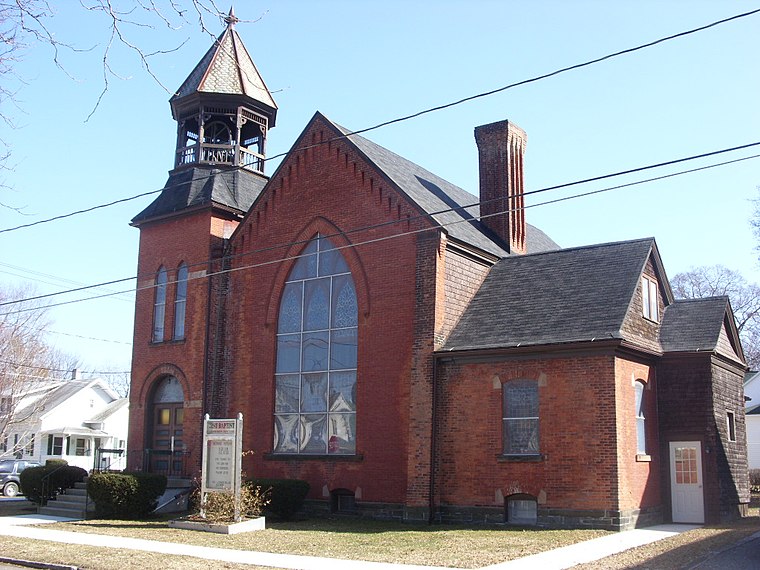
Photo: Doug Kerr, CC BY-SA 2.0.
First Baptist Church of Watkins Glen is a historic Baptist church located at Watkins Glen in Schuyler County, New York. It was built in 1888 and is a Victorian era religious building distinguished by a variety of vernacular Romanesque Revival and Queen Anne style inspired design and decorative detail. First Baptist Church of Watkins Glen is situated 2½ miles north of The Falls Motel.
Places in the Area
Nearby places include Montour Falls and Watkins Glen.
Montour Falls
Village

Photo: Doug Kerr, CC BY-SA 2.0.
Montour Falls is a village located in Schuyler County, New York, United States. The population was 2,714 at the time of the 2020 census. A waterfall at the end of West Main Street gives the village its name.
Watkins Glen

Photo: Amerikaan314, CC BY-SA 3.0.
Watkins Glen is a village and census-designated place in and the county seat of Schuyler County, New York, United States. As of the 2020 census, the population was 1,829.
Odessa
Village
Odessa is a village in Schuyler County, New York, United States. The population was 517 at the 2020 census. The Village of Odessa is in the western side of the Town of Catharine near the town line and is shared with the Town of Montour. Odessa is situated 3½ miles east of The Falls Motel.
The Falls Motel
- Type: Motel
- Address: 239 North Genesee Street, Montour Falls, NY 14865
- Categories: tourism, accommodation, and building
- Location: Montour, Schuyler, New York, Mid-Atlantic, United States, North America
- View on OpenStreetMap
Latitude
42.34791° or 42° 20′ 53″ northLongitude
-76.85269° or 76° 51′ 10″ westOpen location code
87J584XW+5WOpenStreetMap ID
node 3445813408OpenStreetMap feature
tourism=motel
This page is based on OpenStreetMap, Wikidata, and Wikimedia Commons.
We’d love your help improving our open data sources. Thank you for contributing.
Satellite Map
Discover The Falls Motel from above in high-definition satellite imagery.
Notable Places Nearby
Highlights include Village of Montour Falls and Montour Falls Memorial Library.
Nearby Places
Explore places such as Jerlando’s Pizza and Montour Coffee House And Wine Bar.
New York: Must-Visit Destinations
Delve into New York City, Buffalo, Manhattan, and West Side.
Curious Motels to Discover
Uncover intriguing motels from every corner of the globe.
About Mapcarta. Data © OpenStreetMap contributors and available under the Open Database License". Text is available under the CC BY-SA 4.0 license, except for photos, directions, and the map. Photo: Jeffrey Johnson, CC BY-SA 2.0.