Ved Holte St.
Ved Holte St. is a shelter in Rudersdal, Capital Region. Ved Holte St. is situated nearby to Holte railway station, as well as near the marina Holte Havn.| Tap on a place to explore it |
Places of Interest Nearby
Highlights include Holte railway station and Søllerød Town Hall.
Holte railway station
Railway station
Holte station is a railway station serving the suburb of Holte north of Copenhagen, Denmark. It is served by S-trains on the Hillerød radial of Copenhagen's S-train network.
Søllerød Town Hall
Town hall

Photo: Wikimedia, CC BY-SA 3.0.
Søllerød Town Hall, now renamed Rudersdal Town Hall, was built for the former Søllerød Municipality which in 2007 became part of Rudersdal Municipality, combining Søllerød and Birkerød. Søllerød Town Hall is situated 470 metres northeast of Ved Holte St..
Holte Midtpunkt
Shopping center
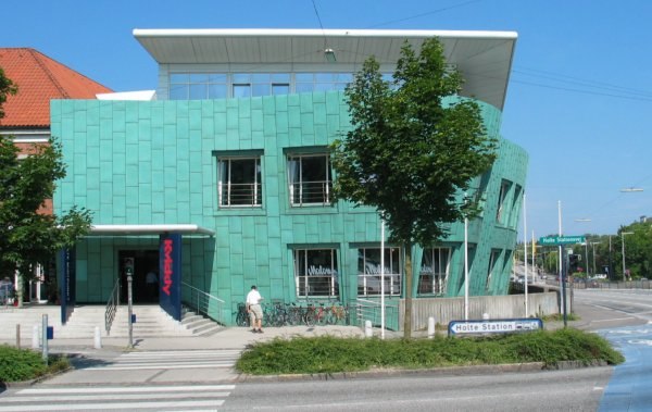
Photo: Hansjorn, CC BY-SA 3.0.
Holte Midtpunkt is a shopping center, which is situated 430 metres northeast of Ved Holte St..
Places in the Area
Nearby places include Holte and Virum.
Holte
Suburb

Photo: Emil Christiansen, CC BY-SA 3.0.
Holte is a suburban district in Rudersdal Municipality on the northern outskirts of Copenhagen, Denmark. The local town centre is centred on Holte station and is surrounded by extensive areas of single-family, detached homes as well as several lakes and forests.
Virum
Suburb
Photo: Bjoertvedt, CC BY-SA 3.0.
Virum is a mostly residential, suburban neighbourhood in Lyngby-Taarbæk Municipality, located on both sides of Lyngby Kongevej, approximately 15 km north of central Copenhagen, Denmark.
Øverød
Suburb
Øverød is a suburban neighborhood situated on the north side of Søllerød Lake in Holte, Rudersdal Municipality, in the northern outskirts of Copenhagen, Denmark.
Ved Holte St.
- Type: Shelter
- Category: bus stop
- Location: Rudersdal, Capital Region, Denmark, Nordic countries, Europe
- View on OpenStreetMap
Latitude
55.80817° or 55° 48′ 29″ northLongitude
12.46824° or 12° 28′ 6″ eastOpen location code
9F7JRF59+77OpenStreetMap ID
node 3667209036OpenStreetMap feature
amenity=shelterOpenStreetMap feature
highway=bus_stopOpenStreetMap feature
public_transport=platform
This page is based on OpenStreetMap, Wikidata, and Wikimedia Commons.
We’d love your help improving our open data sources. Thank you for contributing.
Satellite Map
Discover Ved Holte St. from above in high-definition satellite imagery.
Notable Places Nearby
Highlights include Holte St. and Holte Havn.
Nearby Places
Explore places such as Ved Holte St. and Holte Station.
Denmark: Must-Visit Destinations
Delve into Copenhagen, Aarhus, Odense, and Aalborg.
Curious Shelters to Discover
Uncover intriguing shelters from every corner of the globe.
About Mapcarta. Data © OpenStreetMap contributors and available under the Open Database License". Text is available under the CC BY-SA 4.0 license, except for photos, directions, and the map. Photo: Wikimedia, CC BY-SA 3.0.