Gaztelekuko Osasun Zentroa
Gaztelekuko Osasun Zentroa is a clinic in Bilbao, Biscay, Basque Country. Gaztelekuko Osasun Zentroa is situated nearby to the garden Tiboli lorategiak / Jardines Tíboli, as well as near the public building Edificio San Agustín, Bilbao.| Tap on a place to explore it |
- Opening hours: Monday—Friday 8:00 AM—8:00 PM
- Type: Clinic
- Also known as: “Matiko-Tiboli Osasun Zentroa”
- Address: BILBAO, BIZKAIA 48007
Places of Interest Nearby
Highlights include Guggenheim Museum Bilbao and Edificio San Agustín, Bilbao.
Guggenheim Museum Bilbao
Museum

Photo: Naotake Murayama, CC BY 2.0.
The Guggenheim Museum Bilbao is a museum of modern and contemporary art in Bilbao, Biscay, Spain. It is one of several museums affiliated to the Solomon R. Guggenheim Museum Bilbao is situated 1 km west of Gaztelekuko Osasun Zentroa.
Edificio San Agustín, Bilbao
Public building

Photo: Zarateman, CC BY-SA 3.0.
Edificio San Agustín, Bilbao is a public building, which is situated 130 metres south of Gaztelekuko Osasun Zentroa.
Bilbao City Hall
Town hall
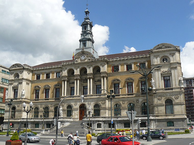
Photo: Fernandopascullo, CC BY-SA 4.0.
The Bilbao City Hall is the seat of the Bilbao City Council, the local ayuntamiento of Bilbao, Spain. The City Hall is located on the right bank of the Estuary of Bilbao across the Puente del Ayuntamiento bascule bridge that links it to the central Abando district. Bilbao City Hall is situated 160 metres south of Gaztelekuko Osasun Zentroa.
Places in the Area
Nearby places include Castaños / Gazteleku and Uribitarte.


Begoña
Quarter
Photo: Fernandopascullo, CC BY 2.5.
Begoña is a historical municipality of Biscay and is a neighbourhood and urban district of Bilbao. Begoña, or more puristically but also more rarely spelled Begoina, means 'the lower foot', referring to the slopes of Mount Artxanda which lie to the north of the city.
Gaztelekuko Osasun Zentroa
- Category: health care
- Location: Bilbao, Biscay, Basque Country, Northern Spain, Spain, Iberia, Europe
- View on OpenStreetMap
Latitude
43.26566° or 43° 15′ 56″ northLongitude
-2.9237° or 2° 55′ 25″ westOperator
OsakidetzaNetwork
Bilbo-Basurtuko ESIOpen location code
8CMV738G+7GOpenStreetMap ID
node 3768932110OpenStreetMap feature
amenity=clinicOpenStreetMap feature
healthcare=clinic
This page is based on OpenStreetMap, Wikidata, and Wikimedia Commons.
We’d love your help improving our open data sources. Thank you for contributing.
Satellite Map
Discover Gaztelekuko Osasun Zentroa from above in high-definition satellite imagery.
In Other Languages
From Basque to Spanish—“Gaztelekuko Osasun Zentroa” goes by many names.
- Basque: “Gaztelekuko Osasun Zentroa”
- Spanish: “Centro de Salud de Gazteleku”
Notable Places Nearby
Highlights include Tiboli lorategiak / Jardines Tíboli and Policía Municipal - Udaltzaingoa (Udaletxea).
Nearby Places
Explore places such as CPEIPS Artxandape Ikastola and Cafeteria Duplex-Buen Café.
Basque Country: Must-Visit Destinations
Delve into San Sebastián, Vitoria-Gasteiz, Guernica, and Irun.
Curious Clinics to Discover
Uncover intriguing clinics from every corner of the globe.
About Mapcarta. Data © OpenStreetMap contributors and available under the Open Database License". Text is available under the CC BY-SA 4.0 license, except for photos, directions, and the map. Photo: Archaeodontosaurus, CC BY-SA 3.0.