Heiga Transporte
Heiga Transporte is an office in Paderborn, Detmold, North Rhine-Westphalia which is located on Am Atlaswerk. Heiga Transporte is situated nearby to the community center Pfarrheim St. Elisabeth, as well as near the library Katholische Öffentliche Bücherei.| Tap on a place to explore it |
Places of Interest Nearby
Highlights include Paderborn Hauptbahnhof and Marktkirche.
Paderborn Hauptbahnhof
Railway station

Photo: Tohma, CC BY-SA 4.0.
Paderborn Hauptbahnhof is the main passenger station in the city of Paderborn in the German state of North Rhine-Westphalia. It is located on the Hamm–Warburg line, part of the Mid-Germany Connection from Cologne or Düsseldorf to Thuringia and Saxony. Paderborn Hauptbahnhof is situated 1½ km north of Heiga Transporte.
Marktkirche
Church

Photo: Tsungam, CC BY-SA 4.0.
Marktkirche is a church, which is situated 2 km north of Heiga Transporte.
Historisches Rathaus Paderborn
Town hall
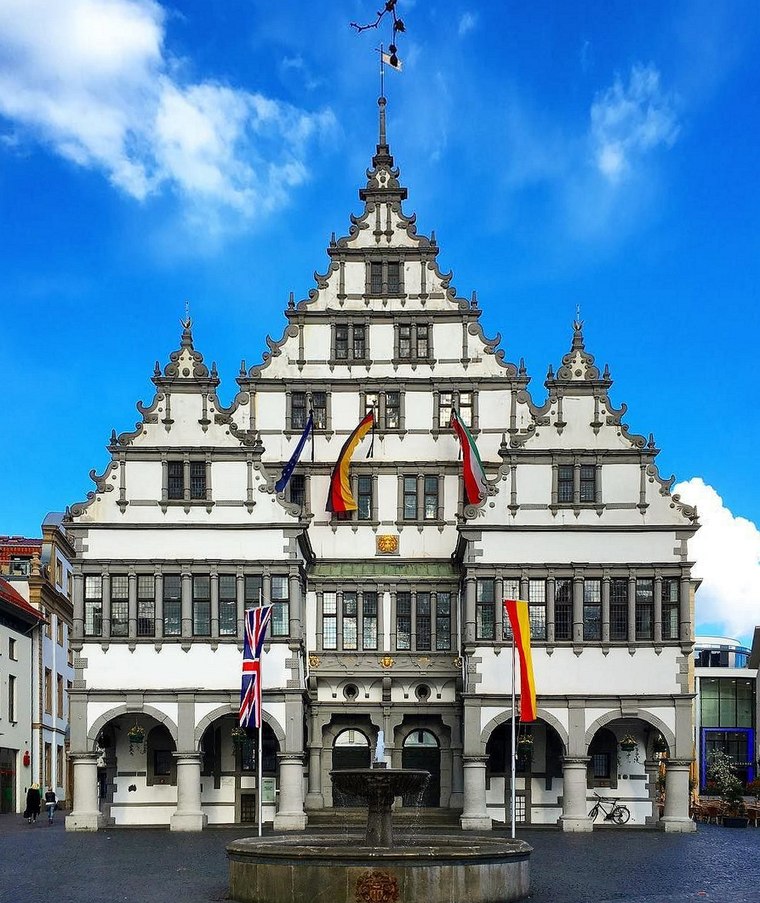
Photo: Sunnysteffen, CC BY-SA 4.0.
Historisches Rathaus Paderborn is a town hall, which is situated 2 km north of Heiga Transporte.
Places in the Area
Nearby places include Borchen and Benhausen.
Borchen
Village

Photo: Unixbook, CC BY-SA 3.0.
Borchen is a municipality in the district of Paderborn, in North Rhine-Westphalia, Germany. Borchen is situated 4½ km south of Heiga Transporte.
Benhausen
Village

Photo: Philipp Sx86, CC BY-SA 3.0.
Benhausen is a village, which is situated 7 km northeast of Heiga Transporte.
Dahl
Village

Photo: The LoW, CC BY-SA 4.0.
Dahl is a village, which is situated 7 km east of Heiga Transporte.
Heiga Transporte
- Type: Logistics
- Address: Am Atlaswerk 18, Paderborn, 33106
- Category: office
- Location: Paderborn, Paderborn, Detmold, Teutoburg Forest, North Rhine-Westphalia, Germany, Central Europe, Europe
- View on OpenStreetMap
Latitude
51.70098° or 51° 42′ 4″ northLongitude
8.74635° or 8° 44′ 47″ eastOpen location code
9F3CPP2W+9GOpenStreetMap ID
node 3804045963OpenStreetMap feature
office=logistics
This page is based on OpenStreetMap, Wikidata, and Wikimedia Commons.
We’d love your help improving our open data sources. Thank you for contributing.
Satellite Map
Discover Heiga Transporte from above in high-definition satellite imagery.
Notable Places Nearby
Highlights include Pfarrheim St. Elisabeth and Katholische Öffentliche Bücherei.
Nearby Places
Explore places such as Motorradsportclub Paderborn 1972 e. V. and PreZero Metall.
Teutoburg Forest: Must-Visit Destinations
Delve into Bielefeld, Detmold, Gütersloh, and Minden.
Curious Places to Discover
Uncover intriguing places from every corner of the globe.
About Mapcarta. Data © OpenStreetMap contributors and available under the Open Database License". Text is available under the CC BY-SA 4.0 license, except for photos, directions, and the map. Photo: Wikimedia, CC0.