Ettlingen Goethe-/Bachstraße
Ettlingen Goethe-/Bachstraße is a bus stop in Ettlingen, Karlsruhe, Baden-Württemberg. Ettlingen Goethe-/Bachstraße is situated nearby to the church Freie evangelische Gemeinde Ettlingen, as well as near Urban Dance School.| Tap on a place to explore it |
Places of Interest Nearby
Highlights include Hans-Bretz-Stadion and Ettlingen West.
Hans-Bretz-Stadion
Stadium

Photo: Püppen, CC BY-SA 4.0.
Hans-Bretz-Stadion is a stadium, which is situated 450 metres south of Ettlingen Goethe-/Bachstraße.
Ettlingen West
Railway station

Photo: Sitacuisses, CC BY-SA 3.0 de.
Ettlingen West is a railway station, which is situated 670 metres northwest of Ettlingen Goethe-/Bachstraße.
Ettlingen Palace
Public building
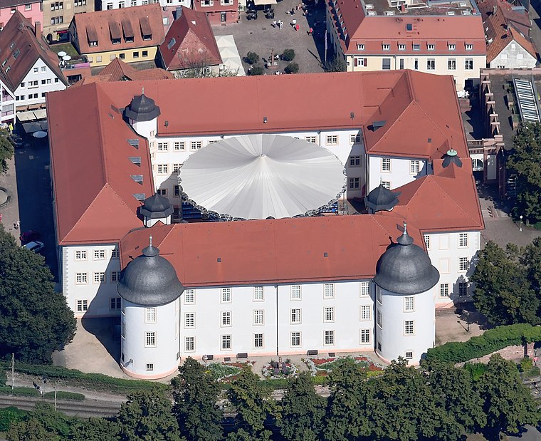
Photo: Carsten Steger, CC BY-SA 4.0.
Ettlingen Palace is a baroque palace in the centre of Ettlingen, a small city in Baden-Württemberg, Germany. Ettlingen Palace is situated 1 km east of Ettlingen Goethe-/Bachstraße.
Places in the Area
Nearby places include Spessart and Waldbronn.
Spessart
Village

Photo: Elwood j blues, CC BY-SA 3.0.
Spessart is a village, which is situated 4½ km southeast of Ettlingen Goethe-/Bachstraße.
Waldbronn
Town

Photo: Spacefrank, CC BY-SA 2.5.
Waldbronn is a municipality in the district of Karlsruhe, in Baden-Württemberg, Germany. It is situated in the northern Black Forest, 11 kilometres southeast of Karlsruhe. Waldbronn is situated 6 km east of Ettlingen Goethe-/Bachstraße.
Wolfartsweier
Suburb
Wolfartsweier is a village and a quarter of Karlsruhe, Baden-Württemberg, Germany. Its population is 3,068. It was first mentioned in 1261 AD under the name of "Wolvoldeswilere". Wolfartsweier is situated 6 km northeast of Ettlingen Goethe-/Bachstraße.
Ettlingen Goethe-/Bachstraße
- Type: Bus stop
- Category: transportation
- Location: Ettlingen, Karlsruhe, Karlsruhe Region, Rhine-Neckar, Baden-Württemberg, Germany, Central Europe, Europe
- View on OpenStreetMap
Latitude
48.94193° or 48° 56′ 31″ northLongitude
8.39241° or 8° 23′ 33″ eastOpen location code
8FWCW9RR+QXOpenStreetMap ID
node 3991011231OpenStreetMap feature
highway=bus_stopOpenStreetMap feature
public_transport=platform
This page is based on OpenStreetMap, Wikidata, and Wikimedia Commons.
We’d love your help improving our open data sources. Thank you for contributing.
Satellite Map
Discover Ettlingen Goethe-/Bachstraße from above in high-definition satellite imagery.
Notable Places Nearby
Highlights include Freie evangelische Gemeinde Ettlingen and Urban Dance School.
Nearby Places
Explore places such as Ettlingen Goethe-/Bachstraße and Ettlingen Sportpark.
Rhine-Neckar: Must-Visit Destinations
Delve into Heidelberg, Karlsruhe, Mannheim, and Heilbronn.
Curious Bus Stops to Discover
Uncover intriguing bus stops from every corner of the globe.
About Mapcarta. Data © OpenStreetMap contributors and available under the Open Database License". Text is available under the CC BY-SA 4.0 license, except for photos, directions, and the map. Photo: Martin-D, CC BY-SA 2.5.