Kødbyens Høker
Kødbyens Høker is a convenience store in Vesterbro-Kongens Enghave, Copenhagen municipality, Capital Region. Kødbyens Høker is situated nearby to the community center Ungdommens Demokratihus, as well as near Forsamlingshuset 5e.| Tap on a place to explore it |
Places of Interest Nearby
Highlights include Copenhagen Central Station and Onkel Dannys Plads.
Copenhagen Central Station
Railway station

Photo: Klockarnils, CC BY-SA 3.0.
Copenhagen Central Station is the main railway station in Copenhagen, Denmark, and the largest railway station in Denmark. With more than 100,000 travellers every day, it is the second busiest station in Denmark after Nørreport station. Copenhagen Central Station is situated 510 metres northeast of Kødbyens Høker.
Onkel Dannys Plads
Square

Photo: Ramblersen, CC BY-SA 4.0.
Onkel Dannys Plads is a square, which is situated 110 metres north of Kødbyens Høker.
Tivoli Gardens
Theme park
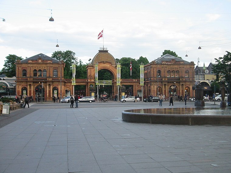
Photo: Elgaard, CC BY-SA 3.0.
Tivoli Gardens, also known simply as Tivoli, is an amusement park and pleasure garden in Copenhagen, Denmark. The park opened on 15 August 1843 and is the second-oldest operating amusement park in the world, after Dyrehavsbakken in nearby Klampenborg, also in Denmark. Tivoli Gardens is situated 690 metres northeast of Kødbyens Høker.
Places in the Area
Nearby places include Meatpacking District and Postbyen.
Meatpacking District
Suburb

Photo: Riemann, Public domain.
Kødbyen is a district of Vesterbro in Copenhagen, Denmark. It is situated between the railway lines going into Copenhagen Central Station and Sønder Boulevard.

Vesterbro

Photo: Dannebrog Spy, CC BY-SA 3.0.
Vesterbro is just outside Copenhagen’s city centre )the Inner City or Indre By), making it a very attractive place to live. It includes the districts of Sydhavnen.
Kødbyens Høker
- Opening hours:
Monday—Friday: 9:00 AM—3:00 PM
Saturday—Sunday: 11:00 AM—3:00 PM - Type: Convenience store
- Categories: shop, fast food restaurant, and food
- Location: Vesterbro-Kongens Enghave, Copenhagen municipality, Capital Region, Denmark, Nordic countries, Europe
- View on OpenStreetMap
Latitude
55.6689° or 55° 40′ 8″ northLongitude
12.5609° or 12° 33′ 39″ eastOpen location code
9F7JMH96+H9OpenStreetMap ID
node 4009579932OpenStreetMap feature
amenity=fast_foodOpenStreetMap feature
shop=convenience
This page is based on OpenStreetMap, Wikidata, and Wikimedia Commons.
We’d love your help improving our open data sources. Thank you for contributing.
Satellite Map
Discover Kødbyens Høker from above in high-definition satellite imagery.
Notable Places Nearby
Highlights include Ungdommens Demokratihus and Forsamlingshuset 5e.
Nearby Places
Explore places such as Falafelboden Christiania and Butchers & Bicycles ApS.
Denmark: Must-Visit Destinations
Delve into Copenhagen, Aarhus, Odense, and Aalborg.
Curious Convenience Stores to Discover
Uncover intriguing convenience stores from every corner of the globe.
About Mapcarta. Data © OpenStreetMap contributors and available under the Open Database License". Text is available under the CC BY-SA 4.0 license, except for photos, directions, and the map. Photo: Wikimedia, CC BY-SA 3.0.